Gol, Norway
| Gol kommune | |||
|---|---|---|---|
| Municipality | |||
|
|||
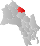
 Gol within Buskerud |
|||
| Coordinates: 60°45′1″N 8°59′5″E / 60.75028°N 8.98472°ECoordinates: 60°45′1″N 8°59′5″E / 60.75028°N 8.98472°E | |||
| Country | Norway | ||
| County | Buskerud | ||
| District | Hallingdal | ||
| Administrative centre | Gol | ||
| Government | |||
| • Mayor (2003) | Jan-Halvard Brekko (Ap) | ||
| Area | |||
| • Total | 533 km2 (206 sq mi) | ||
| • Land | 514 km2 (198 sq mi) | ||
| Area rank | 200 in Norway | ||
| Population (2004) | |||
| • Total | 4,372 | ||
| • Rank | 218 in Norway | ||
| • Density | 8/km2 (20/sq mi) | ||
| • Change (10 years) | 1.4 % | ||
| Demonym(s) | Goling | ||
| Time zone | CET (UTC+1) | ||
| • Summer (DST) | CEST (UTC+2) | ||
| ISO 3166 code | NO-0617 | ||
| Official language form | Nynorsk | ||
| Website | www |
||
|
|
|||
![]() Gol is a municipality in Buskerud county, Norway. It is part of the traditional region of Hallingdal. The administrative centre of the municipality is the village of Gol. Gol was established as a municipality on 1 January 1838 (see formannskapsdistrikt). The area of Hemsedal was separated from Gol in 1897 to become a separate municipality.
Gol is a municipality in Buskerud county, Norway. It is part of the traditional region of Hallingdal. The administrative centre of the municipality is the village of Gol. Gol was established as a municipality on 1 January 1838 (see formannskapsdistrikt). The area of Hemsedal was separated from Gol in 1897 to become a separate municipality.
The municipality of Gol is bordered to the north by the municipality of Nord-Aurdal (in Oppland county), to the east by Sør-Aurdal (in Oppland county), to the south by Nes, and to the west by Ål and Hemsedal.
The Old Norse form of the name was Gǫrð. This is probably an old river name (for the lower part of Hemsil river). The name of the river is maybe derived from the word garðr m 'fence; border' - and the meaning is then 'the border river'.
The coat-of-arms is from modern times. They were granted on 13 September 1985. The arms are gold with three black keys in the center. The keys are derived from the key for the oldest stave church in Gol Gol stave church, which is now in the Norwegian Museum of Cultural History.
...
Wikipedia


