Golßen
| Golßen | ||
|---|---|---|

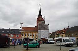
Market square and town hall
|
||
|
||
| Coordinates: 51°58′N 13°36′E / 51.967°N 13.600°ECoordinates: 51°58′N 13°36′E / 51.967°N 13.600°E | ||
| Country | Germany | |
| State | Brandenburg | |
| District | Dahme-Spreewald | |
| Municipal assoc. | Unterspreewald | |
| Government | ||
| • Mayor | Lars Kolan ((SPD)) | |
| Area | ||
| • Total | 63.29 km2 (24.44 sq mi) | |
| Elevation | 58 m (190 ft) | |
| Population (2015-12-31) | ||
| • Total | 2,567 | |
| • Density | 41/km2 (110/sq mi) | |
| Time zone | CET/CEST (UTC+1/+2) | |
| Postal codes | 15938 | |
| Dialling codes | 035452 | |
| Vehicle registration | LDS | |
| Website | www.amt-golssener-land.de | |
Golßen (Lower Sorbian: Gólišyn) is a town in the district of Dahme-Spreewald, in Brandenburg, Germany. It is the administrative seat of the Amt ("municipal federation") Unterspreewald.
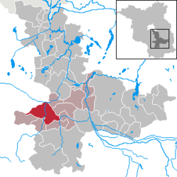
It is situated in the northwest of the Lower Lusatia region, close to the border with the Brandenburgian Mittelmark core territory. The municipal area stretches from the eastern (Lower) Fläming Heath down to the Glogau-Baruth Urstromtal (glacial valley) traversed by the Dahme River. It also comprises the villages of Mahlsdorf and Zützen.
Golßen station is a stop on the Berlin–Dresden railway line. The area around the town is known for the cultivation of Spreewald gherkins.
The settlement arose in the course of the German Ostsiedlung eastward migration during the 11th century, possibly at the site of an earlier Slavic village of fortress. Golsyn in the March of Lusatia was first mentioned in a 1276 deed issued by the Wettin margraves. With the former march, Golßen was purchased by the Luxembourg emperor Charles IV in 1367 and incorporated into the Lands of the Bohemian Crown. The Bohemian kings temporarily put the estates around Golßen Castle in pawn to several holders, such as Margrave William I of Meissen (in 1395).
...
Wikipedia


