Goesdorf
|
Goesdorf Géisdref |
||
|---|---|---|
| Commune | ||
 |
||
|
||
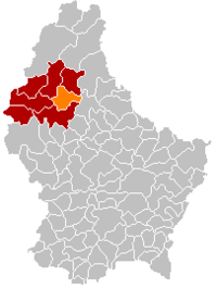
 Map of Luxembourg with Goesdorf highlighted in orange, and the canton in dark red |
||
| Coordinates: 49°55′00″N 5°58′00″E / 49.9167°N 5.9667°ECoordinates: 49°55′00″N 5°58′00″E / 49.9167°N 5.9667°E | ||
| Country |
|
|
| Canton | Wiltz | |
| Government | ||
| • Mayor | Norbert Maes | |
| Area | ||
| • Total | 29.41 km2 (11.36 sq mi) | |
| Area rank | 25 of 105 | |
| Highest elevation | 498 m (1,634 ft) | |
| • Rank | 19th of 105 | |
| Lowest elevation | 233 m (764 ft) | |
| • Rank | 46th of 105 | |
| Population (2014) | ||
| • Total | 1,404 | |
| • Rank | 88th of 105 | |
| • Density | 48/km2 (120/sq mi) | |
| • Density rank | 90th of 105 | |
| Time zone | CET (UTC+1) | |
| • Summer (DST) | CEST (UTC+2) | |
| LAU 2 | LU00005004 | |
| Website | goesdorf.lu | |
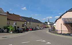
Goesdorf (Luxembourgish: Géisdref) is a commune and village in north-western Luxembourg. It is part of the canton of Wiltz, which is part of the district of Diekirch.
As of 2005[update], the village of Goesdorf, which lies in the south of the commune, had a population of 238. Other towns within the commune include Buderscheid, Dahl, Nocher, and Nocher-Route.
...
Wikipedia

