Glonn
| Glonn | ||
|---|---|---|

View of Glonn from the southwest.
|
||
|
||
| Coordinates: 47°59′N 11°52′E / 47.983°N 11.867°ECoordinates: 47°59′N 11°52′E / 47.983°N 11.867°E | ||
| Country | Germany | |
| State | Bavaria | |
| Admin. region | Upper Bavaria | |
| District | Ebersberg | |
| Government | ||
| • Mayor | Martin Esterl | |
| Area | ||
| • Total | 30.24 km2 (11.68 sq mi) | |
| Elevation | 536 m (1,759 ft) | |
| Population (2015-12-31) | ||
| • Total | 5,081 | |
| • Density | 170/km2 (440/sq mi) | |
| Time zone | CET/CEST (UTC+1/+2) | |
| Postal codes | 85625 | |
| Dialling codes | 08093 | |
| Vehicle registration | EBE | |
| Website | www.markt-glonn.de | |
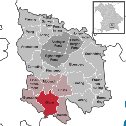
Glonn is a market town in the Ebersberg district in Upper Bavaria, Germany, about 30 km (19 mi) southeast of Munich.
The market town of Glonn is a health spa (Erholungsort), and the Glonn Valley is ringed by wooded hills, carved by the former Inn Glacier. To the south, the Alps are clearly visible on the horizon.
The rivers Glonn, Kupferbach and Schrannenbach rise within Glonn's municipal area, where the lake Kastensee is also to be found. Just inside the neighbouring community of Moosach lies the Steinsee, another lake. Glonn is also home to three protected areas.
Glonn's immediate neighbours are the communities of Baiern, Bruck, Egmating, Moosach and Oberpframmern, which together with Glonn form an administrative community (Verwaltungsgemeinschaft).
The town of Grafing and the centres of Kirchseeon, Zorneding and Höhenkirchen-Siegertsbrunn are about 15 km away. Nevertheless, it is there that regional and long-distance rail service is to be found.
Glonn lies roughly 30 km from the cities of Munich and Rosenheim.
Early settlement in the New Stone Age is witnessed by a number of finds, among them a dwelling pit, weapons and jewellery. The town's name derives from the Celtic description of the local river Glana – "Clear".
...
Wikipedia


