Glenwood City, Wisconsin
| Glenwood City, Wisconsin | |
|---|---|
| City | |
| Nickname(s): city of 57 hills | |
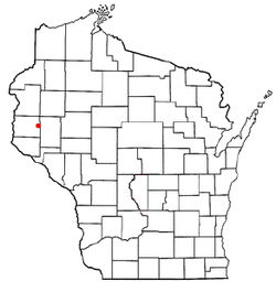
 Location of Glenwood City, Wisconsin |
|
| Coordinates: 45°3′26″N 92°10′12″W / 45.05722°N 92.17000°WCoordinates: 45°3′26″N 92°10′12″W / 45.05722°N 92.17000°W | |
| Country | United States |
| State | Wisconsin |
| County | St. Croix |
| Area | |
| • Total | 2.49 sq mi (6.45 km2) |
| • Land | 2.49 sq mi (6.45 km2) |
| • Water | 0 sq mi (0 km2) |
| Elevation | 1,030 ft (314 m) |
| Population (2010) | |
| • Total | 1,242 |
| • Estimate (2012) | 1,236 |
| • Density | 498.8/sq mi (192.6/km2) |
| Time zone | Central (CST) (UTC-6) |
| • Summer (DST) | CDT (UTC-5) |
| Area code(s) | 715 & 534 |
| FIPS code | 55-29625 |
| GNIS feature ID | 1581635 |
| Website | glenwoodcitywi |
Glenwood City is a city in St. Croix County, Wisconsin, United States. The population was 1,242 at the 2010 census. Glenwood City is the site of the yearly St. Croix County fair and is known as the "City of 57 Hills."
The city was founded on the banks of Tiffany Creek, in 1880. It was once a stop on the Wisconsin Central Railway, but the line to Glenwood City is now abandoned.
Glenwood City is home to the St. Croix County Fair in July, and also hosts a PRCA Rodeo each June.
Glenwood City is located at 45°3′26″N 92°10′12″W / 45.05722°N 92.17000°W (45.057220, -92.169991).
According to the United States Census Bureau, the city has a total area of 2.49 square miles (6.45 km2), all of it land.
As of the census of 2010, there were 1,242 people, 509 households, and 328 families residing in the city. The population density was 498.8 inhabitants per square mile (192.6/km2). There were 561 housing units at an average density of 225.3 per square mile (87.0/km2). The racial makeup of the city was 97.7% White, 0.1% African American, 0.1% Native American, 0.5% Asian, 0.6% from other races, and 1.1% from two or more races. Hispanic or Latino of any race were 1.9% of the population.
...
Wikipedia
