Glenside, Pennsylvania
| Glenside | |
|
Census-designated place Neighborhood of Cheltenham Township |
|
|
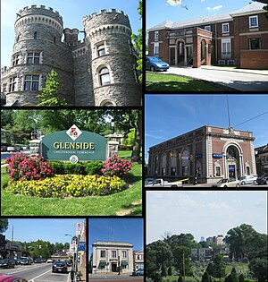
From top left: Grey Towers Castle, Glenside Welcome Sign at Limekiln Pike & Easton Road, Downtown Glenside, Glenside Trust Company Building, Philadelphia Skyline, former Glenside National Bank building, Glenside Memorial Hall
|
|
| Nickname: G Side | |
| Country | |
|---|---|
| State | |
| County | Montgomery |
| Townships | Abington, Cheltenham |
| Elevation | 262 ft (79.9 m) |
| Coordinates | 40°06′11″N 75°09′08″W / 40.10306°N 75.15222°WCoordinates: 40°06′11″N 75°09′08″W / 40.10306°N 75.15222°W |
| Area | 1.3 sq mi (3.4 km2) |
| - land | 1.3 sq mi (3 km2) |
| - water | 0.0 sq mi (0 km2), 0% |
| Population | 8,384 (2010) |
| Density | 6,449.2/sq mi (2,490.1/km2) |
| Timezone | Eastern Standard Time (UTC-5) |
| - summer (DST) | Eastern Daylight Time (UTC-4) |
| ZIP Code | 19038 |
| Area code | 215 and 267 |
| Commissioners | J. Andrew Sharkey Kathy A. Hampton (East) |
Glenside is a census-designated place (CDP) bordering North Philadelphia in Abington and Cheltenham townships, Montgomery County, Pennsylvania, United States. The population was 8,384 at the 2010 census on a land area of only 1.3 square miles. The Glenside station is one of the busiest in the SEPTA system. Glenside is located about 6 miles from Center City Philadelphia.
Glenside is bordered to the South by the West Oak Lane and Cedarbrook neighborhoods of Philadelphia, the East and West by the Cheltenham neighborhoods of Edge Hill, Laverock, and Wyncote, and to the North by the Abington neighborhoods of Ardsley and Abington.
Glenside is located at 40°6′11″N 75°9′8″W / 40.10306°N 75.15222°W (40.102960, −75.152264).
...
Wikipedia


