Glendo, Wyoming
| Glendo, Wyoming | |
|---|---|
| Town | |

Looking east on A Street
|
|
| Motto: "Small in Number - Big in Heart" | |
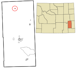
 Location in Platte County and the state of Wyoming. |
|
| Coordinates: 42°30′11″N 105°1′31″W / 42.50306°N 105.02528°WCoordinates: 42°30′11″N 105°1′31″W / 42.50306°N 105.02528°W | |
| Country | United States |
| State | Wyoming |
| County | Platte |
| Area | |
| • Total | 0.53 sq mi (1.37 km2) |
| • Land | 0.53 sq mi (1.37 km2) |
| • Water | 0 sq mi (0 km2) |
| Elevation | 4,724 ft (1,440 m) |
| Population (2010) | |
| • Total | 205 |
| • Estimate (2012) | 205 |
| • Density | 386.8/sq mi (149.3/km2) |
| Time zone | Mountain (MST) (UTC-7) |
| • Summer (DST) | MDT (UTC-6) |
| ZIP code | 82213 |
| Area code(s) | 307 |
| FIPS code | 56-32290 |
| GNIS feature ID | 1588932 |
| Website | Glendo Wyoming |
Glendo is a town in Platte County, Wyoming, United States. The population was 205 at the 2010 census.
The town was incorporated in 1922. The California Trail, Oregon Trail and Mormon Trail passed south of Glendo. The Overland Stage Line also passed south of Glendo.
It was in a cabin near the town that William L. Carlisle, one of America's last train robbers, was captured in December 1919 after a shoot-out with the posse pursuing him.
Glendo is located at 42°30′11″N 105°1′31″W / 42.50306°N 105.02528°W (42.503175, -105.025180).
According to the United States Census Bureau, the town has a total area of 0.53 square miles (1.37 km2), all of it land.
As of the census of 2010, there were 205 people, 101 households, and 59 families residing in the town. The population density was 386.8 inhabitants per square mile (149.3/km2). There were 167 housing units at an average density of 315.1 per square mile (121.7/km2). The racial makeup of the town was 97.1% White, 1.0% Native American, 1.0% from other races, and 1.0% from two or more races. Hispanic or Latino of any race were 3.4% of the population.
...
Wikipedia
