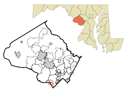
Glen Echo, Maryland
| Glen Echo, Maryland | |
|---|---|
| Town | |
 Location of Glen Echo, Maryland |
|
| Coordinates: 38°58′7″N 77°8′33″W / 38.96861°N 77.14250°WCoordinates: 38°58′7″N 77°8′33″W / 38.96861°N 77.14250°W | |
| Country | |
| State |
|
| County |
|
| Area | |
| • Total | 0.10 sq mi (0.26 km2) |
| • Land | 0.10 sq mi (0.26 km2) |
| • Water | 0 sq mi (0 km2) |
| Elevation | 135 ft (41 m) |
| Population (2010) | |
| • Total | 255 |
| • Estimate (2012) | 262 |
| • Density | 2,550.0/sq mi (984.6/km2) |
| Time zone | Eastern (EST) (UTC-5) |
| • Summer (DST) | EDT (UTC-4) |
| ZIP code | 20812 |
| Area code(s) | 301 |
| FIPS code | 24-32900 |
| GNIS feature ID | 0590313 |
Glen Echo is a town in Montgomery County, Maryland, United States, that was chartered in 1904. The population was 255 at the 2010 census.
Glen Echo derives its name from Edward and Edwin Baltzley, who came up with the name c. 1888. Their advertising booklet for the town was titled "Glen Echo on the Potomac: The Washington Rhine".
The town is famous for its Chautauqua cultural events and its old amusement park, the famous Glen Echo Park, now a U.S. National Park.
Clara Barton, founder of the American Red Cross, lived in Glen Echo the last 15 years of her life.
Glen Echo is located at 38°58′07″N 77°08′33″W / 38.968710°N 77.142451°W.
According to the United States Census Bureau, the town has a total area of 0.10 square miles (0.26 km2), all of it land.
As of the census of 2010, there were 255 people, 96 households, and 66 families residing in the town. The population density was 2,550.0 inhabitants per square mile (984.6/km2). There were 100 housing units at an average density of 1,000.0 per square mile (386.1/km2). The racial makeup of the town was 92.5% White, 1.2% African American, 2.4% Asian, 1.6% from other races, and 2.4% from two or more races. Hispanic or Latino of any race were 3.9% of the population.
...
Wikipedia
