Gleaston
| Gleaston | |
|---|---|
 Gleaston mill |
|
| Gleaston shown within Cumbria | |
| OS grid reference | SD255707 |
| Civil parish | |
| District | |
| Shire county | |
| Region | |
| Country | England |
| Sovereign state | United Kingdom |
| Post town | ULVERSTON |
| Postcode district | LA12 |
| Dialling code | 01229 |
| Police | Cumbria |
| Fire | Cumbria |
| Ambulance | North West |
| EU Parliament | North West England |
| UK Parliament | |
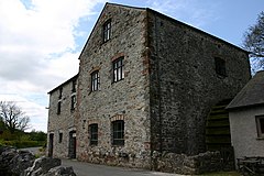
Gleaston is a village with a population of around 400 in the Furness area of South Cumbria, situated between the towns of Barrow-in-Furness, Dalton-in-Furness and Ulverston. Historically in Lancashire, the history of the village can be traced as far back as the mesolithic period and it was the centre of the manor of Muchland in the Middle Ages. Today it is largely a commuter village for the nearby towns, but its past is still visible in the remains of Gleaston Castle and Gleaston Water Mill, which is open as a tourist attraction.
The Domesday Book of 1086 records Gleaston as Glassertun. Joan Lee suggests that this could mean 'farm by a stream' from the Brythonic glas and Old Norse tun, as there is a swift stream or beck running through the village. Alternatively it could mean 'green hill farm' from the Old Norse words glas - haugr - tun. It has also been proposed that the name was derived from the "British words, glas, green, er, fallow or ploughed land, and ton, a town or village.
The greater part of Gleaston, the villages of Leece and Dendron, are included in the parochial parish of St. Matthew Dendron. The ancient village of Leece is built round a tarn and appears twice in the Domesday Book. Lies was listed in the Manor of Hougun held by Earl Tostig.
Archaeological digs in the 1990s brought to light the ancient history of the village. Mesolithic, Neolithic and Bronze Age artifacts were found and the position of a prehistoric lake, which once covered a field between the castle and the mill, was discovered, proving that the local area has been inhabited for thousands of years.
...
Wikipedia

