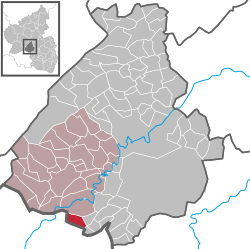
Gimbweiler
| Gimbweiler | ||
|---|---|---|
|
||
| Coordinates: 49°35′08″N 7°11′23″E / 49.58556°N 7.18972°ECoordinates: 49°35′08″N 7°11′23″E / 49.58556°N 7.18972°E | ||
| Country | Germany | |
| State | Rhineland-Palatinate | |
| District | Birkenfeld | |
| Municipal assoc. | Birkenfeld | |
| Government | ||
| • Mayor | Martin Samson (FL) | |
| Area | ||
| • Total | 5.53 km2 (2.14 sq mi) | |
| Elevation | 480 m (1,570 ft) | |
| Population (2015-12-31) | ||
| • Total | 399 | |
| • Density | 72/km2 (190/sq mi) | |
| Time zone | CET/CEST (UTC+1/+2) | |
| Postal codes | 55767 | |
| Dialling codes | 06782 | |
| Vehicle registration | BIR | |
| Website | www.gimbweiler.de | |
Gimbweiler is an Ortsgemeinde – a municipality belonging to a Verbandsgemeinde, a kind of collective municipality – in the Birkenfeld district in Rhineland-Palatinate, Germany. It belongs to the Verbandsgemeinde of Birkenfeld, whose seat is in the like-named town.
The municipality lies on the Mörschbach in the Schwarzwälder Hochwald (forest) in the Hunsrück, on the boundary with the Saarland.
Also belonging to Gimbweiler is the outlying homestead of Heidehof.
The oldest forms of Gimbweiler’s name are Gumbweiler (1397), Gompwiler (1480) and Gympwiler (1480). Gimbweiler may be of Roman origin, as the now vanished hamlet of Frudesweiler may have been, too, but this cannot be proved.
Gimbweiler’s history unfolded much like neighbouring Wolfersweiler’s (nowadays an outlying centre of Nohfelden). Gimbweiler always belonged to that village’s high court and parish, while the lords through the Middle Ages were the Bishops of Verdun, the Counts of Veldenz and the Dukes of Palatinate-Zweibrücken.
In the 13th century, the Lords of Oberstein tried to gain a foothold in the villages that lay between Wolfersweiler and Baumholder. They renewed these attempts in the centuries that followed, bolstered by their enfeoffments from the Duchy of Lorraine.
...
Wikipedia


