Gilpin Township, Armstrong County, Pennsylvania
| Gilpin Township, Pennsylvania | |
|---|---|
| Township | |

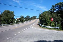
Pennsylvania Route 66 in Gilpin Township
|
|
 Map of Armstrong County, Pennsylvania highlighting Gilpin Township |
|
 Map of Armstrong County, Pennsylvania |
|
| Country | United States |
| State | Pennsylvania |
| County | Armstrong |
| Settled | 1814 |
| Incorporated | 1878 |
| Area | |
| • Total | 17.1 sq mi (44.4 km2) |
| • Land | 16.4 sq mi (42.6 km2) |
| • Water | 0.7 sq mi (1.8 km2) |
| Population (2010) | |
| • Total | 2,496 |
| • Density | 152/sq mi (58.6/km2) |
| Time zone | Eastern (EST) (UTC-5) |
| • Summer (DST) | EDT (UTC-4) |
Gilpin Township is a township in Armstrong County, Pennsylvania, United States. As of the 2010 census it had a population of 2,496.
The Allegheny River Lock and Dam No. 5 was listed on the National Register of Historic Places in 2000.
Pennsylvania Route 66 is the main highway that runs through the township, with Leechburg Borough and Parks Township at each entrance. Gilpin is bordered on the west by the Kiskiminetas River and the Allegheny River. The community of Schenley is located within Gilpin Township at the confluence of the two rivers. Murphy Island is within the township in the Allegheny River.
According to the United States Census Bureau, Gilpin Township has a total area of 17.1 square miles (44.4 km2), of which 16.4 square miles (42.6 km2) is land and 0.69 square miles (1.8 km2), or 4.05%, is water.
As of the census of 2000, there were 2,587 people, 1,034 households, and 768 families residing in the township. The population density was 157.0 people per square mile (60.6/km²). There were 1,114 housing units at an average density of 67.6/sq mi (26.1/km²). The racial makeup of the township was 97.99% White, 1.01% African American, 0.04% Native American, 0.19% Asian, 0.12% Pacific Islander, 0.04% from other races, and 0.62% from two or more races. Hispanic or Latino of any race were 0.19% of the population.
...
Wikipedia
