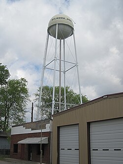
Gilmore, Arkansas
| Gilmore, Arkansas | |
|---|---|
| City | |
 |
|
 Location in Crittenden County and the state of Arkansas |
|
| Coordinates: 35°24′40″N 90°16′39″W / 35.41111°N 90.27750°WCoordinates: 35°24′40″N 90°16′39″W / 35.41111°N 90.27750°W | |
| Country | United States |
| State | Arkansas |
| County | Crittenden |
| Area | |
| • Total | 0.2 sq mi (0.6 km2) |
| • Land | 0.2 sq mi (0.6 km2) |
| • Water | 0 sq mi (0 km2) |
| Elevation | 226 ft (69 m) |
| Population (2010) | |
| • Total | 263 |
| • Density | 1,187/sq mi (458.3/km2) |
| Time zone | Central (CST) (UTC-6) |
| • Summer (DST) | CDT (UTC-5) |
| ZIP code | 72339 |
| Area code(s) | 870 |
| FIPS code | 05-27040 |
| GNIS feature ID | 0057817 |
Gilmore is a city in Crittenden County, Arkansas, United States. The population was 263 at the 2010 census.
Gilmore is located in northern Crittenden County at 35°24′40″N 90°16′39″W / 35.41111°N 90.27750°W (35.411229, -90.277528). It is bordered to the south by the city of Turrell. U.S. Routes 61 and 63 (future Interstate 555) pass west of the center of town, leading northwest 44 miles (71 km) to Jonesboro and south 20 miles (32 km) via Interstate 55 to West Memphis.
According to the United States Census Bureau, Gilmore has a total area of 0.23 square miles (0.6 km2), all land.
As of the census of 2000, there were 292 people, 100 households, and 78 families residing in the town. The population density was 512.5/km² (1,306.1/mi²). There were 114 housing units at an average density of 200.1/km² (509.9/mi²). The racial makeup of the town was 19.86% White, 79.11% Black or African American, 0.68% from other races, and 0.34% from two or more races.
...
Wikipedia
