Gibson Township, Cameron County, Pennsylvania
| Gibson Township, Cameron County, Pennsylvania |
|
|---|---|
| Township | |

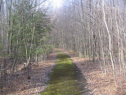
An old road in the Quehanna Wild Area
|
|
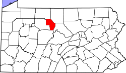
 Map of Cameron County, Pennsylvania highlighting Gibson Township |
|
 Map of Cameron County, Pennsylvania |
|
| Country | United States |
| State | Pennsylvania |
| County | Cameron |
| Settled | 1804 |
| Area | |
| • Total | 94.6 sq mi (244.9 km2) |
| • Land | 93.9 sq mi (243.3 km2) |
| • Water | 0.6 sq mi (1.6 km2) |
| Population (2010) | |
| • Total | 164 |
| • Density | 2/sq mi (0.7/km2) |
| Time zone | Eastern (EST) (UTC-5) |
| • Summer (DST) | EDT (UTC-4) |
| Area code(s) | 814 |
Gibson Township is a township in Cameron County, Pennsylvania, United States. The population was 164 at the 2010 census, down from 222 at the 2000 census.
Gibson Township is in southern Cameron County and is bordered by Lumber Township to the north, Grove Township to the east, Clearfield County to the south and Elk County to the west. The township surrounds the borough of Driftwood but is separate from it.
According to the United States Census Bureau, the township has a total area of 94.6 square miles (244.9 km2), of which 93.9 square miles (243.3 km2) is land and 0.62 square miles (1.6 km2), or 0.67%, is water. The Driftwood Branch and Bennett Branch of Sinnemahoning Creek flow through the township, joining at Driftwood to form Sinnemahoning Creek, which continues east across the township on its way towards the West Branch Susquehanna River.
As of the census of 2000, there were 222 people, 89 households, and 60 families residing in the township. The population density was 2.3 people per square mile (0.9/km²). There were 578 housing units at an average density of 6.1/sq mi (2.4/km²). The racial makeup of the township was 96.40% White, 1.35% Native American, 0.45% Asian, and 1.80% from two or more races. Hispanic or Latino of any race were 1.80% of the population.
...
Wikipedia
