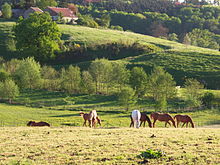
Geul
| Geul | |
|---|---|

Geul river valley in Plombières, Belgium
|
|
| Other name(s) | Göhl, Gueule |
| Country | Belgium, Netherlands |
| Basin features | |
| Main source | near Lichtenbusch ±300 m (980 ft) |
| River mouth |
Meuse near Bunde 50°53′49″N 5°43′4″E / 50.89694°N 5.71778°ECoordinates: 50°53′49″N 5°43′4″E / 50.89694°N 5.71778°E |
| Progression | Meuse→ North Sea |
| Physical characteristics | |
| Length | 58 km (36 mi) |
The Geul (-Dutch, in German: Göhl, in French: Gueule) is a river in Belgium and in the Netherlands, where it is a right-bank tributary to the river Meuse.
The source of the Geul is at about 300 metres (980 ft) above sea level in northeastern Belgium near the German border, south of the German town of Aachen. From there, after flowing some 20 kilometres (12 mi) in a northwestern direction, it leaves Belgium and enters the Netherlands at Cotessen in the Vaals municipality. After a further 38 kilometres (24 mi) in a west-northwestern direction through the most southern part of Limburg, which in its turn is the most southern province of the Netherlands, it flows into the river Meuse, north of the city of Maastricht.
A tributary of the river Geul is the Gulp.
Places through which the Geul passes are among others Kelmis (Belgium), Valkenburg aan de Geul and Meerssen (Netherlands).
The water of the river Geul is polluted seriously with heavy metals zinc and lead and as a result also is a serious source of heavy metal inflow into the Meuse river.
This pollution is a result of former zinc and lead mining activities near the Belgian towns of Kelmis (La Calamine) and Plombières (formerly named Bleiberg).
The last ones of these mines have closed early in the 20th century. One of the reasons for giving up mining activities in Plombières was the occasional flooding of the mine by the river Geul, as the bedrock (mainly Carboniferous limestone) contains many faults and fissures.
...
Wikipedia
