George Washington Carver National Monument
| George Washington Carver National Monument | |
|---|---|
|
IUCN category V (protected landscape/seascape)
|
|
| Location | Newton County, Missouri, US |
| Nearest city | Diamond, Missouri |
| Coordinates | 36°59′11″N 94°21′15″W / 36.986361°N 94.354191°WCoordinates: 36°59′11″N 94°21′15″W / 36.986361°N 94.354191°W |
| Area | 210 acres (85 ha) |
| Authorized | July 14, 1943 |
| Visitors | 30,787 (in 2011) |
| Governing body | National Park Service |
| Website | |
|
George Washington Carver National Monument
|
|

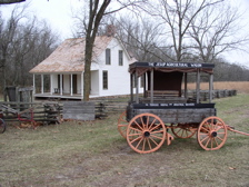
Wagon and 1881 Moses Carver House at George Washington Carver National Monument
|
|
| Nearest city | Diamond, Missouri |
| Area | 210 acres (85 ha) |
| NRHP Reference # | 66000114 |
| Added to NRHP | October 15, 1966 |
George Washington Carver National Monument
George Washington Carver National Monument is a unit of the National Park Service located about two miles west of Diamond, Missouri; the national monument was founded on July 14, 1943, by Franklin Delano Roosevelt, who dedicated $30,000 to the monument. It was the first national monument dedicated to a black American and first to a non-president.
The site preserves of the boyhood home of George Washington Carver, as well as the 1881 Moses Carver house and the Carver cemetery. His boyhood home consists of rolling hills, woodlands, and prairies. The 240-acre (97 ha) park has a 3⁄4-mile (1.2 km) nature trail, film, museum, and an interactive exhibit area for students. It is open year-round, from 9 am to 5 pm.
It was listed on the National Register of Historic Places in 1966.
...
Wikipedia


