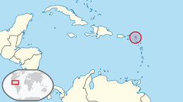
Geography of Sint Maarten
|
Native name: Sint Maarten (Dutch) Saint-Martin (French) Nickname: The Friendly Island |
|
|---|---|
 |
|
| Geography | |
| Location | Caribbean Sea |
| Coordinates | 18°04′N 63°03′W / 18.067°N 63.050°WCoordinates: 18°04′N 63°03′W / 18.067°N 63.050°W |
| Archipelago | Leeward Islands, Lesser Antilles |
| Area | 87 km2 (34 sq mi) |
| Highest elevation | 414 m (1,358 ft) |
| Highest point | Pic Paradis |
| Administration | |
|
French Republic
|
|
| Overseas collectivity | Saint Martin |
| Capital and largest settlement | Marigot (pop. 5,700) |
| Area covered | 53 km2 (20 sq mi; 60.9%) |
|
Kingdom of the Netherlands
|
|
| Constituent country | Sint Maarten |
| Capital | Philipsburg |
| Largest settlement | Lower Prince's Quarter (pop. 8,123) |
| Area covered | 34 km2 (13 sq mi; 39.1%) |
| Demographics | |
| Demonym | St. Martiner (French); St. Maartener (Dutch) |
| Population | 77,741 (January 1, 2009) |
| Pop. density | 892 /km2 (2,310 /sq mi) |
| Ethnic groups | Afro-Caribbean, Caucausian, Chinese, Indian, mixed |
Saint Martin (French: Saint-Martin; Dutch: Sint Maarten) is an island in the northeast Caribbean, approximately 300 km (190 mi) east of Puerto Rico. The 87-square-kilometre (34 sq mi) island is divided roughly 60/40 between the French Republic (53 km2, 20 sq mi) and the Kingdom of the Netherlands (34 km2, 13 sq mi); but the two parts are roughly equal in population, with slightly more people living on the Dutch side. It is the smallest inhabited island divided between two nations. The division dates to 1648. The southern Dutch part comprises Sint Maarten and is one of four constituent countries that form the Kingdom of the Netherlands. The northern French part comprises the Collectivité de Saint-Martin (Collectivity of St Martin) and is an overseas collectivity of France.
On 1 January 2009, the population of the whole island was 77,741 inhabitants, with 40,917 living on the Dutch side, and 36,824 on the French side.
Collectively, the two territories are known as "St-Martin / St Maarten". Sometimes "SXM", the IATA identifier for Princess Juliana International Airport (the island's main airport), is used to refer to the island. St. Martin (the French portion) received the ISO 3166-1 code MF in October 2007. The Dutch part changed in status to a country within the Kingdom of the Netherlands in 2010 and was given the code SX.
Saint Martin has a land area of 87 km2 (34 sq mi), 53 km2 (20 sq mi) of which is under the sovereignty of France, and 34 km2 (13 sq mi) under the sovereignty of the Kingdom of the Netherlands. This is the only land border shared by France and the Kingdom of the Netherlands anywhere on Earth, the country Sint Maarten being the sharing part of the Kingdom of the Netherlands.
...
Wikipedia

