Geography of Kosovo
 |
|
| Continent | Europe |
|---|---|
| Region | Balkans |
| Coordinates | 42°36′00″N 20°51′00″E / 42.6000°N 20.8500°E |
| Area | Ranked 169th |
| • Total | 10,887 km2 (4,203 sq mi) |
| • Land | 99% |
| • Water | 1% |
| Borders | |
| Highest point |
Gjeravica, 2,656 m (8,714 ft) |
| Lowest point |
White Drin, 297 m (974 ft) |
| Longest river |
White Drin, 122 km (76 mi) |
| Largest lake |
Lake Gazivoda 9.2 km2 (4 sq mi) |
| Climate | Continental |
| Terrain | Mountainous |
| Natural Resources | nickel, lead, zinc, magnesium, lignite, kaolin, chrome, bauxite |
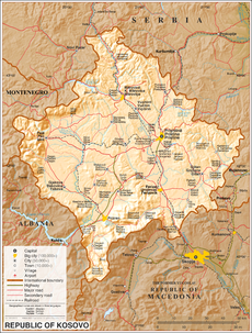
Kosovo is a small landlocked country in Southeastern Europe, in the center of Balkan Peninsula. With an area of 10,908 km2 (4,212 sq mi), it is one of the smallest countries in Europe.
Considering it's small area, Kosovo has a variety of topographical features. It is surrounded by mountains: the Sharr Mountains are located in the south and southeast, bordering Macedonia, while the Kopaonik Mountains rise in the north. The southwest borders with Montenegro and Albania are also mountainous, and home to the country's highest peak, Gjeravica, 2,656 m (8,714 ft) high. The central region is mainly hilly, but two large plains spread over Kosovo's west and east, respectively, Metohija plain and Kosovo plain.
In the terms of hydrography, Kosovo has limited water resources. The main rivers in the country are the White Drin, running towards the Adriatic Sea, the South Morava in the Goljak area, and Ibar in the north. Sitnica, a tributary of Ibar, is the longest river lying completely within Kosovo. There are several small natural lakes but the country's most important lakes are artificial. The biggest lakes are Gazivoda, Radonjić, Batlava and Badovac. Kosovo also does have a large number of karst springs, thermal and mineral water springs.
...
Wikipedia
