Geography of Ghana
| Republic of Ghana | |
|---|---|
 |
|
 |
|
| Continent | Africa |
| Geographic coordinates | 8°00′N 2°00′W / 8.000°N 2.000°W |
| Area | Ranked 82nd |
| - Total | 238,533 km2 |
| - % water | 3.5% (8,520 km2) |
| Coastline | 539 km |
| Highest point | Mount Afadja, 885 m |
| Lowest point | Atlantic Ocean, 0 m |
| Longest river | Volta |
| Largest inland body of water | Lake Volta |
| Land Use | |
| - Arable land | 20.66 % |
| - Permanent crops | 11.87 % |
| - Other | 67.48% (2012) |
| Irrigated land | 309 km2 (2003) |
| Climate | Tropical |
| Natural resources | industrial minerals, gold, timber, industrial diamonds, bauxite, manganese, fish, rubber, hydropower, petroleum, natural gas, silver, salt, limestone |
| Environmental issues | drought, deforestation, overgrazing, soil erosion, poaching, habitat destruction, water pollution |
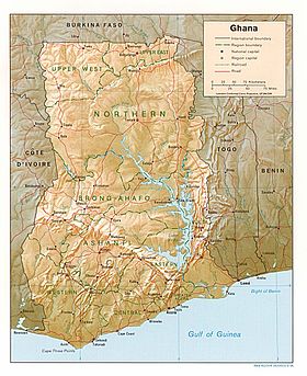
Ghana is a country in Africa, along the Gulf of Guinea, just a few degrees north of the equator. ![]()
Ghana encompasses plains, low hills, rivers, Lake Volta, the world's largest artificial lake, Dodi Island and Bobowasi Island on the south Atlantic Ocean coast of Ghana. Ghana can be divided into four different geographical ecoregions; the coastline is mostly a low, sandy shore backed by plains and scrub and intersected by several rivers and streams while the northern part of Ghana features high plains. South-west and south-central Ghana is made up of a forested plateau region consisting of the Ashanti uplands and the Kwahu Plateau; the hilly Akwapim-Togo ranges are found along Ghana's eastern international border.
The Volta Basin takes up most of south-central Ghana and Ghana's highest point is Mount Afadja which is 885 m (2,904 ft) and is found in the Akwapim-Togo ranges. The climate is tropical and the eastern coastal belt is warm and comparatively dry, the south-west corner of Ghana is hot and humid, and the north of Ghana is hot and dry.Lake Volta, the world's largest artificial lake, extends through large portions of south-eastern Ghana and many tributary rivers such as the Oti and Afram rivers flow into it. The northernmost part of Ghana is Pulmakong and the southernmost part of Ghana is Cape three points near Axim. Ghana lies between latitudes 4° and 12°N. South Ghana contains evergreen and semi-deciduous forests consisting of trees such as mahogany, odum, ebony and it also contains much of Ghana's oil palms and mangroves with shea trees, baobabs and acacias found in the northern part of Ghana.
...
Wikipedia
