Geography of Europe
|

|
|
| Area | 10,180,000 km2 (3,930,000 sq mi) (6th) |
|---|---|
| Population | 742,452,000 (2013; 3rd) |
| Pop. density | 72.9/km2 (188/sq mi) (2nd) |
| Demonym | European |
| Countries |
50 sovereign states 5 with limited recognition |
| Dependencies | 4 dependencies |
| Languages | ~225 languages |
| Time zones | UTC−1 to UTC+5 |
Several of the oldest cities of Northwestern Europe are highlighted in this astronaut's photograph from 00:25 GMT on 10 August 2011
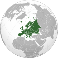
Europe is traditionally defined as one of seven continents. Physiographically, it is the northwestern peninsula of the larger landmass known as Eurasia (or the larger Afro-Eurasia); Asia occupies the eastern bulk of this continuous landmass and all share a common continental shelf. Europe's eastern frontier is delineated by the Ural Mountains in Russia. The southeast boundary with Asia is not universally defined, but the modern definition is generally the Ural River or, less commonly, the Emba River. The boundary continues to the Caspian Sea, the crest of the Caucasus Mountains (or, less commonly, the Kura River in the Caucasus), and on to the Black Sea. The Bosporus, the Sea of Marmara, and the Dardanelles conclude the Asian boundary. The Mediterranean Sea to the south separates Europe from Africa. The western boundary is the Atlantic Ocean. Iceland, though on the Mid-Atlantic Ridge and nearer to Greenland (North America) than mainland Europe, is generally included in Europe for cultural reasons and because it is over twice as close to mainland Europe than to mainland North America. There is ongoing debate on where the geographical centre of Europe falls.
...
Wikipedia

