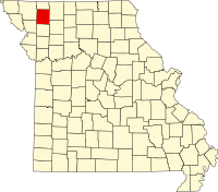
Gentry County, Missouri
| Gentry County, Missouri | |
|---|---|

Gentry County Courthouse in Albany
|
|
 Location in the U.S. state of Missouri |
|
 Missouri's location in the U.S. |
|
| Founded | February 14, 1841 |
| Named for | Richard Gentry |
| Seat | Albany |
| Largest city | Albany |
| Area | |
| • Total | 492 sq mi (1,274 km2) |
| • Land | 491 sq mi (1,272 km2) |
| • Water | 0.3 sq mi (1 km2), 0.06% |
| Population (est.) | |
| • (2015) | 6,692 |
| • Density | 14/sq mi (5/km²) |
| Congressional district | 6th |
| Time zone | Central: UTC-6/-5 |
| Website | gentrycounty |
| Gentry County, Missouri | ||||
|---|---|---|---|---|
| Elected countywide officials | ||||
| Assessor | Sheryl Coburn | Democratic | ||
| Circuit Clerk | Janet Parsons | Republican | ||
| County Clerk | Carol Reidlinger | Democratic | ||
| Collector | Linda Combs | Democratic | ||
|
Commissioner (Presiding) |
Rod Dollars | Republican | ||
|
Commissioner (District 1) |
Larry B. Wilson | Democratic | ||
|
Commissioner (District 2) |
Gary Carlson | Republican | ||
| Coroner | Andrew E. Lindner | Republican | ||
| Prosecuting Attorney | Jeromy Y. Biggs,Jr. | Democratic | ||
| Public Administrator | Joy L. Novak | Democratic | ||
| Recorder | Janet Parsons | Republican | ||
| Sheriff | Tim Davis | Democratic | ||
| Surveyor | John Dole | Democratic | ||
| Treasurer | Linda Combs | Democratic | ||
| Gentry County, Missouri | ||
|---|---|---|
| 2008 Republican primary in Missouri | ||
| John McCain | 217 (36.90%) | |
| Mike Huckabee | 182 (30.95%) | |
| Mitt Romney | 155 (26.36%) | |
| Ron Paul | 23 (3.91%) | |
| Gentry County, Missouri | ||
|---|---|---|
| 2008 Democratic primary in Missouri | ||
| Hillary Clinton | 409 (53.32%) | |
| Barack Obama | 312 (40.68%) | |
| John Edwards (withdrawn) | 38 (4.95%) | |
Gentry County is a county located in the northwestern portion of the U.S. state of Missouri. As of the 2010 census, the population was 6,738. Its county seat is Albany. The county was organized February 14, 1841 and named for Colonel Richard Gentry of Boone County who fell in the Seminole War in 1837.
According to the U.S. Census Bureau, the county has a total area of 492 square miles (1,270 km2), of which 491 square miles (1,270 km2) is land and 0.3 square miles (0.78 km2) (0.06%) is water.
As of the census of 2010, there were 6,738 people, 2,674 households, and 1,789 families residing in the county. The population density was 14 people per square mile (5/km²). There were 3,209 housing units at an average density of 6 per square mile (3/km²). The racial makeup of the county was 98.38% White, 0.31% Black or African American, 0.27% Asian, 0.19% Native American, 0.16% from other races, and 0.68% from two or more races. 0.53% of the population were Hispanic or Latino of any race.
...
Wikipedia
