Geneva County, Alabama
| Geneva County, Alabama | |
|---|---|

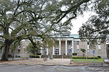
The Geneva County Courthouse in Geneva
|
|
 Location in the U.S. state of Alabama |
|
 Alabama's location in the U.S. |
|
| Founded | December 26, 1868 |
| Named for | Geneva, New York |
| Seat | Geneva |
| Largest city | Geneva |
| Area | |
| • Total | 579 sq mi (1,500 km2) |
| • Land | 574 sq mi (1,487 km2) |
| • Water | 4.5 sq mi (12 km2), 0.8% |
| Population (est.) | |
| • (2015) | 26,777 |
| • Density | 47/sq mi (18/km²) |
| Congressional district | 2nd |
| Time zone | Central: UTC-6/-5 |
| Website | www |
|
Footnotes:
|
|
Footnotes:
Geneva County is a county of the U.S. state of Alabama. As of the 2010 census, the population was 26,790. Its county seat is Geneva. The county was named after its county seat, which in turn was named after Geneva, New York which was named after Geneva, Switzerland, by Walter H. Yonge, an early town resident and Swiss native. Geneva County is a prohibition or dry county.
Geneva County is part of the Dothan, AL Metropolitan Statistical Area.
Geneva County was established on December 26, 1868.
The county was declared a disaster area in September 1979 due to damage from Hurricane Frederic.
On March 10, 2009, a gunman, identified as Michael McLendon, went on a shooting spree at nine locations in Geneva County from the town of Samson to the city of Geneva, killing ten people and wounding six others. McLendon entered his former place of employment, Reliable Metal Products on the northeastern side of Geneva, where he took his own life.
According to the U.S. Census Bureau, the county has a total area of 579 square miles (1,500 km2), of which 574 square miles (1,490 km2) is land and 4.5 square miles (12 km2) (0.8%) is water. It is the fifth-smallest county in Alabama by total area.
Whereas according to the 2010 census Bureau:
As of the census of 2000, there were 25,764 people, 10,477 households, and 7,459 families residing in the county. The population density was 45 people per square mile (17/km2). There were 12,115 housing units at an average density of 21 per square mile (8/km2). The racial makeup of the county was 87.11% White, 10.65% Black or African American, 0.76% Native American, 0.12% Asian, 0.02% Pacific Islander, 0.62% from other races, and 0.72% from two or more races. 1.76% of the population were Hispanic or Latino of any race.
...
Wikipedia
