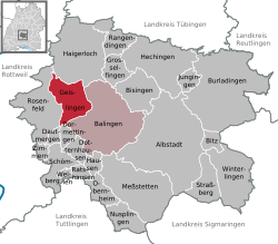
Geislingen, Zollernalbkreis
| Geislingen | ||
|---|---|---|
|
||
| Coordinates: 48°17′15″N 08°48′45″E / 48.28750°N 8.81250°ECoordinates: 48°17′15″N 08°48′45″E / 48.28750°N 8.81250°E | ||
| Country | Germany | |
| State | Baden-Württemberg | |
| Admin. region | Tübingen | |
| District | Zollernalbkreis | |
| Government | ||
| • Mayor | Oliver Schmid (non-Party) | |
| Area | ||
| • Total | 31.95 km2 (12.34 sq mi) | |
| Elevation | 563 m (1,847 ft) | |
| Population (2015-12-31) | ||
| • Total | 5,910 | |
| • Density | 180/km2 (480/sq mi) | |
| Time zone | CET/CEST (UTC+1/+2) | |
| Postal codes | 72349–72351 | |
| Dialling codes | 07433 / 07428 | |
| Vehicle registration | BL/HCH | |
| Website | www.stadt-geislingen.de | |
Geislingen is a town in the Zollernalbkreis district, in Baden-Württemberg, Germany. It is situated 4 km northwest of Balingen. Current population is at around 6,000 people. Geislingen consists of three smaller towns, Geislingen (pop. 4,500), Erlaheim (pop. 500) and Binsdorf (pop. 1,000), all of them growing by about 1% per year. While the area has been constantly settled since the stone age, the first written documentation of Binsdorf dates back to the year 834, Geislingen proper gets a first mention in 1188. The local economy mixes agriculture with services and small-scale industry. Most of Geislingen today has a residential character with many citizens working in the highly industrial areas south of Stuttgart or in nearby Balingen.
In former times sand and ironore was produced in Geislingen.The name of the mine in Geislingen was Goldhöhle. From a old 3,5 km mine in a Doggererzflöz in Weilheim is wood in the Tuttlinger Fruchtkasten . Steel was produced in Tuttlingen by the Schwäbische Hüttenwerke in Ludwigshal. The ofen in Harras was closed in 1832. By building railways new calculations make the ironore of the area unprofitable.
In Geislingen was broken a blach stone for the Operation Desert (German fuel project) near the road to Erzingen .
...
Wikipedia


