Gayndah, Queensland
|
Gayndah Queensland |
|||||||||||||
|---|---|---|---|---|---|---|---|---|---|---|---|---|---|

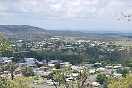
Gayndah, seen from the town lookout
|
|||||||||||||
| Coordinates | 25°38′0″S 151°36′0″E / 25.63333°S 151.60000°ECoordinates: 25°38′0″S 151°36′0″E / 25.63333°S 151.60000°E | ||||||||||||
| Population | 1,789 (2011 census) | ||||||||||||
| Established | 1849 | ||||||||||||
| Postcode(s) | 4625 | ||||||||||||
| Elevation | 106 m (348 ft) | ||||||||||||
| Location |
|
||||||||||||
| LGA(s) | North Burnett Region | ||||||||||||
| State electorate(s) | Callide | ||||||||||||
| Federal Division(s) | Flynn | ||||||||||||
|
|||||||||||||
|
|||||||||||||
Gayndah /ˈɡeɪndə/ is a town and locality in the North Burnett Region, Queensland, Australia. In the 2011 census, Gayndah had a population of 1,789 people.
Gayndah is on the Burnett River and the Burnett Highway passes through the town. Apart from the town in the western part of the locality, the land is used for cropping and grazing. The Gayndah railway station is located on the north side of the river and is on the Mungar Junction to Monto Branch railway line.
Duchess Mountain is immediately to the south-west of the town (25°38′00″S 151°36′47″E / 25.63333°S 151.61306°E) and at 190 metres (620 ft) provides excellent views over the town (100 metres (330 ft) above sea level).
Gayndah is 366 kilometres (227 mi) north of the state capital, Brisbane, and 145 kilometres (90 mi) west of the regional city of Maryborough.
Exploration of the Gayndah area began in 1847 by explorer Archer and Surveyor James Charles Burnett (1815-1854). The first European settlers arrived in 1848, and the town was established in the following year. A post office was established at Gayndah in 1850. This suggests that Gayndah may be the oldest officially Gazetted town in Queensland though, it should be noted that, a convict colony of 47 people existed on the Brisbane River, CBD site in 1825. This is known as the 1824 Colony.
...
Wikipedia

