Gaulanitis
|
Golan Heights هضبة الجولان רמת הגולן |
|
|---|---|

Lake Ram near Mount Hermon (background), in the northeastern Golan Heights
|
|
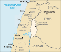
 Location of the Golan Heights |
|
| Coordinates: 32°58′54″N 35°44′58″E / 32.98167°N 35.74944°ECoordinates: 32°58′54″N 35°44′58″E / 32.98167°N 35.74944°E | |
| Status | Internationally recognized as Syrian territory occupied by Israel |
| Area | |
| • Total | 1,800 km2 (700 sq mi) |
| • Occupied by Israel | 1,200 km2 (500 sq mi) |
| • UNDOF control | 235 km2 (91 sq mi) |
| Highest elevation | 2,814 m (9,232 ft) |
| Lowest elevation | -212 m (−696 ft) |
The Golan Heights (Arabic: هضبة الجولان Haḍbatu 'l-Jawlān or مرتفعات الجولان Murtafaʻātu l-Jawlān, Hebrew: רמת הגולן, Ramat HaGolan ![]() (audio) ), or simply the Golan or the Syrian Golan, is a region in the Levant. The western two-thirds of the Golan Heights are currently occupied and administrated by Israel, whereas the eastern third is controlled by Syria, with the UNDOF maintaining a buffer zone in between, to implement the ceasefire of the Purple Line.
(audio) ), or simply the Golan or the Syrian Golan, is a region in the Levant. The western two-thirds of the Golan Heights are currently occupied and administrated by Israel, whereas the eastern third is controlled by Syria, with the UNDOF maintaining a buffer zone in between, to implement the ceasefire of the Purple Line.
The exact region defined as the Golan Heights is different in different disciplines:
The earliest evidence of human habitation dates to the Upper Paleolithic period. According to the Bible, an Amorite Kingdom in Bashan was conquered by Israelites during the reign of King Og. Throughout the Old Testament period, the Golan was "the focus of a power struggle between the Kings of Israel and the Aramaeans who were based near modern-day Damascus." The Itureans, an Arab or Aramaic people, settled there in the 2nd century BCE and remained until the end of the Byzantine period. Organized Jewish settlement in the region came to an end in 636 CE when it was conquered by Arabs under Umar ibn al-Khattāb. In the 16th century, the Golan was conquered by the Ottoman Empire and was part of the Vilayet of Damascus until it was transferred to French control in 1918. When the mandate terminated in 1946, it became part of the newly independent Syrian Arab Republic.
...
Wikipedia
