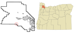
Gaston, Oregon
| Gaston, Oregon | |
|---|---|
| City | |
 |
|
 Location in Oregon |
|
| Location in the United States | |
| Coordinates: 45°26′11″N 123°8′29″W / 45.43639°N 123.14139°WCoordinates: 45°26′11″N 123°8′29″W / 45.43639°N 123.14139°W | |
| Country | United States |
| State | Oregon |
| County | Washington |
| Incorporated | 1914 |
| Government | |
| • Mayor | Tony Hall |
| Area | |
| • Total | 0.28 sq mi (0.73 km2) |
| • Land | 0.28 sq mi (0.73 km2) |
| • Water | 0 sq mi (0 km2) |
| Elevation | 300 ft (90 m) |
| Population (2010) | |
| • Total | 637 |
| • Estimate (2012) | 658 |
| • Density | 2,275.0/sq mi (878.4/km2) |
| Time zone | Pacific (UTC-8) |
| • Summer (DST) | Pacific (UTC-7) |
| ZIP code | 97119 |
| Area code(s) | 503 and 971 |
| FIPS code | 41-28100 |
| GNIS feature ID | 1157988 |
| Website | http://www.cityofgaston.com |
Gaston is a city in Washington County, Oregon, United States. The population was 637 at the 2010 census.
Prior to the arrival of European immigrants in the 1800s, little is known about Native American settlements in the Gaston area. What is known indicates that Native Americans in the area lived similarly to other Pacific Northwest tribes. In nearby Cherry Grove there are a few petroglyphs usually credited to the Atfalati tribe, which is a division of Kalapuya. Diseases such as smallpox, malaria and influenza which were brought to North America by European Settlers, decimated local native American population. By the time Europeans began to significantly settle the region, as much as 90% of the original native populations had been killed.
In the 1860s, the census recorded only about 70 people in the Gaston area. Nonetheless, in 1866, the first Gaston School was founded. In 1870, a new school was built near the connecting road between Old Highway 47 and the new Highway 47. Initially students only attended school for three to six months per year, later expanded to nine months. In 1871, as a stage coach line brought more settlers, and in anticipation of a new rail line, railroad developer and town namesake Joseph Gaston set aside 2 acres (0.81 ha) of land on what was then the edge of town for a school.
In the early 1870s, stagecoach and rail service was expanding rapidly in Washington County. By 1872, a stop on the Portland – St. Joseph line in Patton Valley was officially named Gaston. With a train stop, more people came and by 1873 a post office opened in the new town. The same year, the first church, Gaston Congregational Church, was also built. In the 1880s, Joseph Gaston was responsible for draining Wapato Lake, which lay in the valley around the rail stop, creating the farmland that exists today. "Wapato" is a word from the local Indians that refers to a water-based starchy root vegetable related to arrowroot sometimes called a "water potato" in local English. Rail service ended in 1985 with the removal of rails back to the junction to the Seghers spur.
...
Wikipedia

