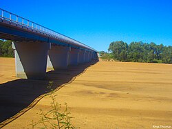
Gascoyne River (Western Australia)
| Gascoyne | |
| River | |
|
The Gascoyne riverbed near Carnarvon
|
|
| Name origin: Captain John Gascoyne RN, son of Bamber Gascoyne | |
| Country | Australia |
|---|---|
| State | Western Australia |
| Region | Gascoyne |
| Tributaries | |
| - left | Landor River, Thirty One River, Lyons River |
| - right | Thomas River |
| City | Carnarvon |
| Primary source | Collier Range |
| - location | Three Rivers Station |
| - elevation | 514 m (1,686 ft) |
| - coordinates | 24°39′8″S 119°44′58″E / 24.65222°S 119.74944°E |
| Secondary source | Gascoyne River (Middle) |
| - location | west of Beyondie Lakes |
| - coordinates | 25°20′42″S 119°38′53″E / 25.34500°S 119.64806°E |
| Additional source | Gascoyne River (South) |
| - location | near the Doolgunna homestead |
| - coordinates | 25°41′45″S 119°13′17″E / 25.69583°S 119.22139°E |
| Source confluence | Gascoyne River (North) |
| - coordinates | 25°18′29″S 119°6′42″E / 25.30806°S 119.11167°E |
| Mouth | Indian Ocean |
| - location | Shark Bay |
| - elevation | 0 m (0 ft) |
| - coordinates | 24°52′14″S 113°36′57″E / 24.87056°S 113.61583°ECoordinates: 24°52′14″S 113°36′57″E / 24.87056°S 113.61583°E |
| Length | 865 km (537 mi) |
| Basin | 76,254 km2 (29,442 sq mi) |
| Natural pools | Tibingoona Pool; Bibbingoona Pool; Nungamarra Pool; Mibbley Pool; Mutherbukin Pool; Beelu Pool; Bilyarra Pool; Piddendoora Pool; and Gnardune Pool |
The Gascoyne River is a river in the Gascoyne region of Western Australia. At 865 kilometres (537 mi), it is the longest river in Western Australia.
The Gascoyne River comprises three branches in its upper reaches. Draining the Collier Range, the river rises as the Gascoyne River (North Branch) on Three Rivers Station near the Great Northern Highway, 100 kilometres (62 mi) northeast of Peak Hill and flows for approximately 125 kilometres (78 mi). The Gascoyne River (Middle Branch) rises west of Beyondie Lakes, east of Kumarina and east of the Great Northern Highway and flows for approximately 15 kilometres (9.3 mi). The Gascoyne River (South Branch) rises near the Doolgunna homestead and flows for approximately 15 kilometres (9.3 mi). The Gascoyne flows generally west by southwest and is joined by 36 tributaries including the Lyons River, Landor River, Thomas River, and numerous other creeks and gullies. The two main rivers, the Gascoyne and Lyons together provide a catchment area of 68,326 square kilometres (26,381 sq mi) that lies entirely to the east of the Kennedy Ranges and extends some 480 kilometres (298 mi) inland. The river reaches its mouth as it flows into Shark Bay and the Indian Ocean at Carnarvon. The river descends 514 metres (1,686 ft) over its 865-kilometre (537 mi) course.
...
Wikipedia

