Garvagh
Garvagh
|
|
|---|---|
 |
|
| Garvagh shown within Northern Ireland | |
| Population | 1,288 |
| • Belfast | 50 mi (80 km) |
| District | |
| County | |
| Country | Northern Ireland |
| Sovereign state | United Kingdom |
| Post town | Coleraine |
| Postcode district | BT51 |
| Dialling code | 028, +44 28 |
| EU Parliament | Northern Ireland |
| UK Parliament | |
| NI Assembly | |
Garvagh (pronounced /ˈɡɑːrvə/ GAR-və, from Irish: Garbhach, meaning "rough place" or Garbhachadh meaning "rough field") is a village in County Londonderry, Northern Ireland. It is on the banks of the Agivey River, 18 kilometres (11 mi) south of Coleraine on the A29 route. In the 2001 Census it had a population of 1,288. It is situated within Causeway Coast and Glens district.
Garvagh was important from very early times, and later rebuilt as a Plantation town, as its broad main street and neatly planned buildings evidence.
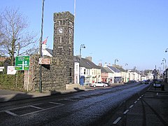
It was founded in the early 17th century by George Canning from Warwickshire, agent for the Ironmonger’s Company of London, it was later grown into a middling-size market town by the Cannings. A striking feature of the town is the stone clock tower with an attractive clock and castellations, which dominates the main route through the town and also serves as the district cenotaph.
On 26 July 1813 the Battle of Garvagh took place. Four hundred Catholic Ribbonmen attempted to destroy a tavern in Garvagh where the Orange Lodge met. They were armed with sticks and bludgeons, but Protestants were waiting inside armed with muskets and repelled them. Several of the Ribbonmen were killed and the rest fled. The town has been immortalised in the famous Protestant folk-song "The Battle of Garvagh".
...
Wikipedia

