Gariwerd
|
Grampians National Park / Gariwerd Victoria |
|
|---|---|
|
IUCN category II (national park)
|
|

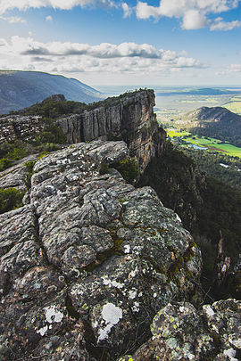
Grampians National Park / Gariwerd viewed from north of Boroka Peak
|
|
| Nearest town or city | Halls Gap |
| Coordinates | 37°12′28″S 142°23′59″E / 37.20778°S 142.39972°ECoordinates: 37°12′28″S 142°23′59″E / 37.20778°S 142.39972°E |
| Established | 1 July 1984 |
| Area | 1,672.19 km2 (645.6 sq mi) |
| Managing authorities | Parks Victoria |
| Website | Grampians National Park |
| See also | Protected areas of Victoria |
The Grampians National Park (also Gariwerd), commonly referred to as The Grampians, is a national park located in the Grampians region of Victoria, Australia. The 167,219-hectare (413,210-acre) national park is situated between Stawell and Horsham on the Western Highway and Dunkeld on the Glenelg Highway, 260 kilometres (160 mi) west of Melbourne and 460 kilometres (290 mi) east of Adelaide. Proclaimed as a national park on 1 July 1984, the park was listed on the Australian National Heritage List on 15 December 2006 for its outstanding natural beauty and being one of the richest indigenous rock art sites in south-eastern Australia. The Grampians feature a striking series of sandstone mountain ranges.
Named Gariwerd by one of the local Australian Aboriginal languages, either the Jardwadjali or Djab Wurrung language, the ranges were given their European name in 1836 by Surveyor General of New South Wales Sir Thomas Mitchell after the Grampian Mountains in his native Scotland. After a two-year consultation process, the park was renamed Grampians (Gariwerd) National Park in 1991, however this controversial formality was reversed after a change of state government in 1992. The Geographic Place Names Act, 1998 (Vic) reinstated dual naming for geographical features, and this has been subsequently adopted in the park based on Jardwadjali and Djab Wurrung names for rock art sites and landscape features with the National Heritage List referring to "Grampians National Park (Gariwerd)".
...
Wikipedia

