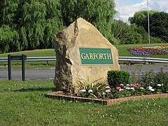
Garforth
| Garforth | |
|---|---|
 Entering from the west on the A63 road |
|
| Garforth shown within West Yorkshire | |
| Population | 19,811 (Ward. Garforth and Swillington.2011) |
| OS grid reference | SE403330 |
| • London | 165 mi (266 km) SSE |
| Metropolitan borough | |
| Metropolitan county | |
| Region | |
| Country | England |
| Sovereign state | United Kingdom |
| Post town | LEEDS |
| Postcode district | LS25 |
| Dialling code | 0113 |
| Police | West Yorkshire |
| Fire | West Yorkshire |
| Ambulance | Yorkshire |
| EU Parliament | Yorkshire and the Humber |
| UK Parliament | |
See also People named Garforth.
Garforth /ˈɡɑːrfərθ/ is a village within the City of Leeds metropolitan borough, in West Yorkshire, England. The 2001 Census lists 23,892 residents in the Garforth and Swillington ward: 80.57% of whom are homeowners, 20% more than the average for Leeds. Historically part of the West Riding of Yorkshire, Garforth itself has 15,394 of those people,. The ward population was 19,811 at the 2011 Census. Garforth was in the parliamentary constituency of Elmet until the 2010 general election, when it was incorporated into the new constituency of Elmet and Rothwell. Garforth's population decreased to 14,957 in 2011.
Garforth owes its size to expansion in the 17th and 18th centuries during which the local land-owning Gascoigne family ran several coalmines in the area. The surrounding settlements of Micklefield, Kippax, Swillington, Methley and Allerton Bywater Great and Little Preston are all villages that prospered and grew as a result of the coal industry. Nowadays manufacturing and motor-vehicle repair account for more than a third of the workforce in the area
...
Wikipedia

