Gangaridai
| Gangaridai Kingdom | ||||||||||
|
||||||||||
|
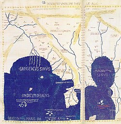
Gangaridai in Ptolemy's Map.
|
||||||||||
| Capital | Kotalipara, Bengal (modern day Bangladesh) | |||||||||
| Religion | ||||||||||
| Government | Monarchy | |||||||||
| Historical era | Ancient India | |||||||||
| • | Established | est. 300 BCE | ||||||||
| • | Disestablished | unknown | ||||||||
|
||||||||||
| Today part of | ||||||||||
| Warning: Value not specified for "" | ||||||||||
Gangaridai (Greek: Γανγαρίδαι; Latin Gangaridae) was an ancient region corresponding to the Ganges delta region of the Indian subcontinent, which was mentioned in the records of numerous Greco-Roman writers. The term means "nation of the Ganges" in Greek and Latin. It is one of the earliest references to the Bengal region in the Indian subcontinent (now divided between Bangladesh and the Indian state of West Bengal). According to ancient Indian records, the Vanga Kingdom and Samatata Kingdom occupied the region during the same period. The capital of the Gangaridai was situated at Kotalipara in present-day Gopalganj District, Bangladesh.
The region was described as a kingdom with one of the largest cavalries of chariots and war elephants. It was described by the Greek traveller Megasthenes in his work Indica. Greek and Roman historians suggested that Alexander the Great withdrew from the Indian subcontinent, anticipating a counterattack from an alliance of Gangaridai and the Nanda Empire. Later writers noted merchant shipping links between Gangaridai's cities and Roman Egypt.
Ptolemy (c. 90 – c. 168), wrote that the Gangaridai occupied the entire region about the five mouths of the Ganges and that the royal residence was in the city of "Ganges". The five mouths were the Kambyson, the Mega, the Kamberikhon, the Pseudostomon and the Antibole. These rivers may refer to the Meghna, Padma, Jamuna, Karnaphuli and Rupsa. Ptolemy also noted a large natural harbour in the Chittagong coastline.
...
Wikipedia

