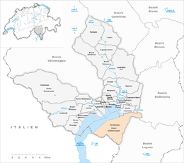
Gambarogno
| Gambarogno | ||
|---|---|---|

Vira (Gambarogno) village
|
||
|
||
| Coordinates: 46°6′N 08°46′E / 46.100°N 8.767°ECoordinates: 46°6′N 08°46′E / 46.100°N 8.767°E | ||
| Country | Switzerland | |
| Canton | Ticino | |
| District | Locarno | |
| Government | ||
| • Mayor |
Sindaco Tiziano Ponti |
|
| Area | ||
| • Total | 51.8 km2 (20.0 sq mi) | |
| Elevation | 196 m (643 ft) | |
| Population (Dec 2015) | ||
| • Total | 5,136 | |
| • Density | 99/km2 (260/sq mi) | |
| Postal code | 6573 | |
| SFOS number | 5398 | |
| Localities | Caviano, Contone, Gerra Gambarogno, Indemini, Magadino, Piazzogna, San Nazzaro, Sant'Abbondio and Vira Gambarogno | |
| Website |
http://www.gambarogno.ch SFSO statistics |
|
Gambarogno is a municipality in the district of Locarno in the canton of Ticino in Switzerland. It was created on 25 April 2010 through the merger of the municipalities of Caviano, Contone, Gerra, Indemini, Magadino, Piazzogna, San Nazzaro, Sant'Abbondio and Vira.
Caviano is first mentioned in 1258 as Caviliano. Contone is first mentioned in 1152 as Gondono. The name Gerra is probably from the 18th Century, when the village of Ronco de Martignoni (which was first mentioned in 1591) expanded into the Gerra river delta and the shores of Lake Maggiore. Indemini is first mentioned in 1260 as Indemine. Magadino is first mentioned in 1254 as de Magadino. It was also previously known, in German, as Megadin though this name is no longer used. Piazzogna is first mentioned in 1337 as Piazognia. San Nazzaro is first mentioned in 1258 as sancto Nazario. Sant'Abbondio is first mentioned in 1192 as Sancto Abundio.
In 1264 and again in 1365, the Bishop of Como transferred part of the tithes of the Gambarogno valley, including Caviano and Scaiano, to the Magoria and Duno families from Locarno. Caviano originally belonged to the parish of Locarno, then in 1558 to Sant'Abbondio. It became a separate parish in 1850. The old church, the foundation is pre-Roman, was demolished in 1864 after the completion of the new church of S. Maria Nascente. Due to limited fishing and farming land, much of the population emigrated to other cantons or countries. The old outskirts of the village is still easily visible. In the settlement of Cento Campi, there were a number of alpine shelters and barns with thatched roofs, though most have fallen into disrepair. This type of shelter/barn was commonly used on the pastures (monti) around Lake Maggiore.
...
Wikipedia


