Gallatin County, Kentucky
| Gallatin County, Kentucky | |
|---|---|

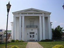
Gallatin County Courthouse in Warsaw
|
|
 Location in the U.S. state of Kentucky |
|
 Kentucky's location in the U.S. |
|
| Founded | 1798 |
| Named for | Albert Gallatin |
| Seat | Warsaw |
| Largest city | Warsaw |
| Area | |
| • Total | 105 sq mi (272 km2) |
| • Land | 101 sq mi (262 km2) |
| • Water | 3.5 sq mi (9 km2), 3.3% |
| Population | |
| • (2010) | 8,589 |
| • Density | 85/sq mi (33/km²) |
| Congressional district | 4th |
| Time zone | Eastern: UTC-5/-4 |
| Website | gallatincounty |
Gallatin County, is a county in the U.S. state of Kentucky. As of the 2010 census, the population was 8,589. Its county seat is Warsaw. The county was founded in 1798 and named for Albert Gallatin, the Secretary of the Treasury under President Thomas Jefferson.
Gallatin County is included in the Cincinnati-Middletown, OH-KY-IN Metropolitan Statistical Area. It is located along the Ohio River across from Indiana.
The county was formed on December 14, 1798. Gallatin was the 31st Kentucky county to be established. It was derived from parts of Franklin and Shelby counties. Later, parts of the county were pared off to create three additional counties: Owen in 1819, Trimble in 1836 and Carroll in 1838. Today Gallatin is one tenth of its original size. Its northern border is the Ohio River.
The population of Gallatin County in 1800 was 1,291, according to the Second Census of Kentucky, composed of 960 whites, 329 slaves, and 2 "freemen of color".
During the Civil War, several skirmishes occurred in the county and the Union Army arrested a number of men for treason for supporting the Confederates.
The 1866 Gallatin County Race Riot happened just after the Civil War, when bands of lawless Ku Klux Klansmen terrorized parts of the Bluegrass State. "A band of five hundred whites in Gallatin County... forced hundreds of blacks to flee across the Ohio River."
...
Wikipedia
