Galbally, County Limerick
|
Galbally An Gallbhaile
|
|
|---|---|
| Village | |

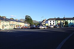
View looking south from the village square
|
|
| Location in Ireland | |
| Coordinates: 52°24′04″N 8°17′46″W / 52.401°N 8.296°WCoordinates: 52°24′04″N 8°17′46″W / 52.401°N 8.296°W | |
| Country | Ireland |
| Province | Munster |
| County | County Limerick |
| Elevation | 112 m (367 ft) |
| Population (2006) | |
| • Urban | 257 |
| Irish Grid Reference | R798278 |
Galbally (Irish: An Gallbhaile, meaning "town of the stranger or the foreigner") is a village in southeast County Limerick, Ireland, on the border with County Tipperary. It is located at the foot of the Galtee Mountains and at the western approach to the Glen of Aherlow. The Aherlow River, flowing down from the Galtee mountains, runs by the village, to meet the Suir at Kilmoyler a short distance north of Cahir. Galbally is in quite a picturesque location, in a valley overlooked by the Galtee Mountains.
Galbally is part of the Catholic ecclesiastical parish of Galbally & Lisvernane which straddles the Limerick-Tipperary border. Its sister village is Lisvernane in the Glen of Aherlow in County Tipperary.
In 1994, Galbally was selected as the prettiest town in Ireland in the annual Irish Tidy Towns Competition and has won the Limerick competition nine times.
A well known folk song, "The Galbally Farmer", (with a tune also known as "Thank God we're surrounded by water"), tells of the trials suffered by a hired labourer working for the miserly farmer of the title, Darby O'Leary.
The graveyard contains the ruins of a thirteenth-century church, on the end wall of which there are two effigies of odd human figures, one which looks like a couple, the other a single person. The graveyard bears witness to the reason for name of the village, with many of the oldest graves bearing what seem more like English names than native Irish, names including; Sampson, Blackburn, Richardson and Dawson.
It is worth noting that the nearby village of Ballylanders is in fact Baile an Londraigh, or "town of the Londoner", again highlighting, toponymically at least, the immigration of English settlers into the area, while the precise obverse of this toponymic heritage is the case of Anglesborough, a tiny village 6 miles (9.7 km) from Galbally, nestled right up against the foot of the mountains, and which "earned" its present name as a perverse retribution from the English surveyors for the fact that it was one of the last outposts of spoken Irish in the area. That the old Irish names of two villages, now transcribed into an odd English, should bear testimony to immigration and the new English name of a third be testament to a cultural resistance, whether willed or not, is just another metaphor of the split culture that historically occurred in Ireland.
...
Wikipedia

