Güssing
| Güssing | ||
|---|---|---|
 |
||
|
||
| Location within Austria | ||
| Coordinates: 47°4′N 16°19′E / 47.067°N 16.317°ECoordinates: 47°4′N 16°19′E / 47.067°N 16.317°E | ||
| Country | Austria | |
| State | Burgenland | |
| District | Güssing | |
| Government | ||
| • Mayor | Peter Vadasz | |
| Area | ||
| • Total | 49.31 km2 (19.04 sq mi) | |
| Elevation | 229 m (751 ft) | |
| Population (1 January 2016) | ||
| • Total | 3,660 | |
| • Density | 74/km2 (190/sq mi) | |
| Time zone | CET (UTC+1) | |
| • Summer (DST) | CEST (UTC+2) | |
| Postal code | 7540 | |
| Website | www.guessing.co.at | |
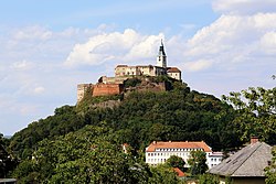
Güssing (Hungarian: Németújvár, Német-Újvár, Croatian: Novi Grad) is a town in Burgenland, Austria. It is located at 47°4′N 16°19′E / 47.067°N 16.317°E, with a population of 3,811 (2011), and is the administrative center of the Güssing district.
The Güssing Castle, built in 1157, is the oldest castle in Burgenland and a regional landmark.
The lords of Güssing (in Hungarian: Kőszeg, in Slovak: Kysak) were a noble family in the frontier region of Austria and the Kingdom of Hungary. Note that Kőszeg is the name of a nearby Hungarian town (known as Güns in German) to which that family moved its residence from Güssing in 1274. In 1522, it became the residence of the Batthyány family, one of the most distinguished Magnate families in Hungary.
Burgenland was, some 15 years ago, the poorest and least developed region of Austria. The Güssing region was one of the poorest within Burgenland.
Güssing, a major town in south Burgenland, a district comprising around 27,000 inhabitants, is the first community in the European Union to produce its whole energy demand – electricity, heating/cooling, fuels – out of renewable resources, all resources from within the region. However, to appreciate the enormity of this achievement, you need to rewind and go back to 1988 when Güssing was one of the poorest areas in Austria. Then, the community relied on agriculture, with farmers selling corn, sunflower oil and timber to make a living. While in terms of tourism, the main/only attraction was a 12th-century castle built by Hungarian nobles. On account of the geographically unfavourable location near the border, major trade or industrial businesses did not exist at that time and the whole district did not have any transportation infrastructure at all (neither railroad nor highway). This resulted in a scarcity of jobs, 70% weekly commuters to Vienna and a high rate of migration to other regions. At the time, the town was said to be hardly able to afford its annual €6 million (£4.7million) fuel bill. To change this situation the “reformers” realised that substantial capital outflow from the region is due to the town’s energy being bought from outside sources. This included oil, power and fuels, while existing resources e.g. 45% forest land, remained largely unused. Thus the “reformers” proposed to abandon fossile energy and start producing and subsequently selling energy to the citizens (customers) themselves. So they wanted to keep that € 6 Million (value for 1992, based on conventional energy prices of that year) in the city.
...
Wikipedia


