Gösenroth
| Gösenroth | ||
|---|---|---|
 |
||
|
||
| Coordinates: 49°53′22.69″N 7°19′32.46″E / 49.8896361°N 7.3256833°ECoordinates: 49°53′22.69″N 7°19′32.46″E / 49.8896361°N 7.3256833°E | ||
| Country | Germany | |
| State | Rhineland-Palatinate | |
| District | Birkenfeld | |
| Municipal assoc. | Rhaunen | |
| Government | ||
| • Mayor | Albert Echternacht | |
| Area | ||
| • Total | 4.49 km2 (1.73 sq mi) | |
| Elevation | 430 m (1,410 ft) | |
| Population (2015-12-31) | ||
| • Total | 246 | |
| • Density | 55/km2 (140/sq mi) | |
| Time zone | CET/CEST (UTC+1/+2) | |
| Postal codes | 55624 | |
| Dialling codes | 06544 | |
| Vehicle registration | BIR | |
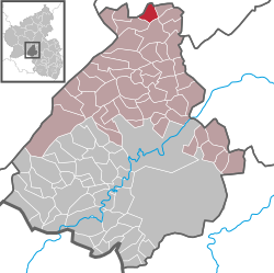
Gösenroth is an Ortsgemeinde – a municipality belonging to a Verbandsgemeinde, a kind of collective municipality – in the Birkenfeld district in Rhineland-Palatinate, Germany. It belongs to the Verbandsgemeinde of Rhaunen, whose seat is in the like-named municipality.
The municipality lies in the Hunsrück, east of the Idar Forest. To its east is the Kyrbach valley.
Gösenroth is a linear village (by some definitions of the word, a thorpe).
Gösenroth’s neighbours are Laufersweiler, Schwerbach, Rhaunen and Weitersbach. All but Laufersweiler, which lies in the Rhein-Hunsrück-Kreis, lie within the Birkenfeld district.
The oldest archaeological finds that yield evidence of settlement within what are now Gösenroth’s limits come from the first and early second century AD. These finds were made in 1936 by the Landesmuseum Trier (Trier State Museum) on the road between Gösenroth and Schwerbach (bordering on Laufersweiler). While some woods were being cleared, seven barrows were discovered. Unearthed by digs at these barrows were, among other things, an iron hatchet, several amphorae, pots, urns, a spindle whorl, a pair of fibulae, two coins (one with Emperor Nero’s effigy from sometime between AD 64 and 68) and a bronze armband. In the latest of these graves (2nd century AD), an iron stylus was found. It was also believed that some of the finds were from an abode of some kind.
...
Wikipedia


