Furnas
| Furnas | |
| Civil Parish | |
|
The Furnas Valley and town, as seen from the Pico do Gaspar Belvedere
|
|
| Official name: Freguesia das Furnas | |
| Name origin: Portuguese for caverns | |
| Country | |
|---|---|
| Autonomous Region | |
| Island | São Miguel |
| Municipality | Povação |
| Center | Furnas |
| - elevation | 207 m (679 ft) |
| - coordinates | 37°46′20″N 25°18′47″W / 37.77222°N 25.31306°WCoordinates: 37°46′20″N 25°18′47″W / 37.77222°N 25.31306°W |
| Highest point | Pico do Salto do Cavalo |
| - elevation | 723.7 m (2,374 ft) |
| - coordinates | 37°47′20″N 25°17′22″W / 37.78889°N 25.28944°W |
| Lowest point | Sea Level |
| - location | Atlantic Ocean |
| Area | 34.43 km2 (13 sq mi) |
| - land | 31.7 km2 (12 sq mi) |
| - water | 1.94 km2 (1 sq mi) |
| - urban | .79 km2 (0 sq mi) |
| Population | 1,439 (2011) |
| Density | 42/km2 (109/sq mi) |
| Settlement | fl. 1522 |
| LAU | Junta Freguesia |
| - location | Rua Enginheiro Clemente Soares Chão da Ribeira |
| - elevation | 204 m (669 ft) |
| - coordinates | 37°46′35″N 25°18′50″W / 37.77639°N 25.31389°W |
| President Junta | Delmar Carvalho Medeiros |
| President Assembleia | Antonio Jose Carvalho (PSD) |
| Timezone | Azores (UTC-1) |
| - summer (DST) | Azores (UTC0) |
| Postal Zone | 9675-012 |
| Area Code & Prefix | (+351) 292 XXX-XXXX |
| Demonym | Furnense |
| Patron Saint | Nossa Senhora da Luz |
| Website: http://www.jffurnas.com/ | |
| Statistics from INE (2001); geographic detail from Instituto Geográfico Português (2010) | |
| Furnas | |
|---|---|
| Vale das Furnas | |

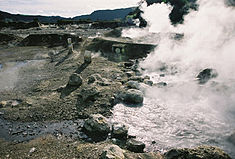
Hot-springs in the central village of Furnas, São Miguel
|
|
| Highest point | |
| Elevation | 198 m (650 ft) |
| Prominence | 795 m (2,608 ft) |
| Coordinates | 37°46′21″N 25°18′14″W / 37.77250°N 25.30389°W |
| Geography | |
| Location | São Miguel, Azores |
| Parent range | Volcanic Complex of Furnas |
| Geology | |
| Age of rock | 30000 |
| Mountain type | Stratovolcano |
| Volcanic arc/belt | Volcanic arc |
| Last eruption | September to November 1630 |
Furnas is a civil parish in the municipality of Povoação on the island of São Miguel in the Portuguese Azores. The population in 2011 was 1,439, in an area of 34.43 km². The parish is one of the largest in the island and in the Azores. It is located east of Lagoa and Ponta Delgada, west of Povoação and southeast of Ribeira Grande.
One of the earliest references to Furnas came from the harvesting of trees in the valley of Furnas, in order to assist the construction of many of the homes destroyed by the 1522 earthquakes and landslides in Vila Franca do Campo. This includes numerous trees used to rebuild the parochial church, a project begun by Donatary-Captain Rui Gonçalves da Câmara. In 1553, his predecessor Manuel da Câmara, issued an edict to re-plant these trees after the area was nearly deforested, and roadways were expanded under his son, Rui Gonçalves da Câmara, in order to develop the area, allowing cattle herding in the valley after 1577.
Still during the tenure of Manuel da Câmara, a chapel was constructed to the invocation of Nossa Senhora da Consolação (Our Lady of Consolation) in 1613, and small residence built for the local priest (who was responsible for masses and the lighting of a lamp in the sacristy). More homes soon appeared in this area around 1615, and a small convent was constructed near the chapel. In 1630, as a consequence of a volcanic eruption in the valley, the area was abandoned. But, new settlers quickly returned to the Furnas valley (mostly from Ponta Garça, Povoação, Vila Franca and Maia) as the land became fertile and better able to sustain a larger population. New roads were constructed on orders between 1682–83, donated by the Baron of Larangeiras.
...
Wikipedia

