Fukaya, Saitama
|
Fukaya 深谷市 |
|||
|---|---|---|---|
| City | |||

Fukaya City Hall
|
|||
|
|||
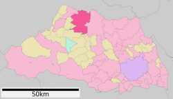
 Location of Fukaya in Saitama Prefecture |
|||
| Coordinates: 36°11′50.9″N 139°16′53.4″E / 36.197472°N 139.281500°ECoordinates: 36°11′50.9″N 139°16′53.4″E / 36.197472°N 139.281500°E | |||
| Country | Japan | ||
| Region | Kantō | ||
| Prefecture | Saitama Prefecture | ||
| Area | |||
| • Total | 138.37 km2 (53.42 sq mi) | ||
| Population (February 2016) | |||
| • Total | 143,696 | ||
| • Density | 1,040/km2 (2,700/sq mi) | ||
| Time zone | Japan Standard Time (UTC+9) | ||
| - Tree | Camellia | ||
| - Flower | Tulip | ||
| Phone number | 048-571-1211 | ||
| Address | 11-1 Nakamachi, Fukaya-shi, Saitama-ken 366-8501 | ||
| Website | Official website | ||
Fukaya (深谷市 Fukaya-shi?) is a city located in northern Saitama Prefecture, in the central Kantō region of Japan. As of 1 February 2016[update], the city had an estimated population of 144,696 and a population density of 1040 persons per km². Its total area was 138.37 square kilometres (53.42 sq mi). It is famous for a variety of welsh onions or Fukaya-negi (深谷ネギ?).
Fukaya is located on the northern border of Saitama Prefecture, in the flatlands of the Kantō plain. Both the Tone River and the Ara River flow through the city.
Fukaya was the site of a castle built by the Uesugi clan in 1456, and later the site of Okabe Domain a feudal domain under the Tokugawa shogunate. In the Edo era, Fukaya-shuku was a major post town on the Nakasendō (中山道) highway, boasting over 80 inns.
...
Wikipedia


