Fujieda, Shizuoka
|
Fujieda 藤枝市 |
|||
|---|---|---|---|
| City | |||

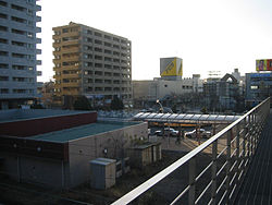
View from Fujieda Station
|
|||
|
|||
 Location of Fujieda in Shizuoka Prefecture |
|||
| Coordinates: 34°52′2.7″N 138°15′27.8″E / 34.867417°N 138.257722°ECoordinates: 34°52′2.7″N 138°15′27.8″E / 34.867417°N 138.257722°E | |||
| Country | Japan | ||
| Region | Chūbu (Tōkai) | ||
| Prefecture | Shizuoka Prefecture | ||
| Area | |||
| • Total | 194.06 km2 (74.93 sq mi) | ||
| Population (September 2015) | |||
| • Total | 143,582 | ||
| • Density | 740/km2 (1,900/sq mi) | ||
| Time zone | Japan Standard Time (UTC+9) | ||
| - Tree | Pine | ||
| - Flower | Wisteria | ||
| - Bird | Japanese bush warbler | ||
| Phone number | 054-643-3111 | ||
| Address | 1-11-1 Okadeyama, Fujieda-shi, Shizuoka-ken 426-8722 | ||
| Website | Official website | ||
Fujieda (藤枝市 Fujieda-shi?) is a city located in Shizuoka Prefecture, Japan. As of September 2015, the city has an estimated population of 143,587 and a population density of 740 persons per km². The total area was 194.03 square kilometres (74.92 sq mi).
Fujieda is located in the Shida Plateau in central Shizuoka Prefecture between the Abe River and the Ōi River. The area enjoys a warm maritime climate with hot, humid summers and mild, cool winters.
Under the Tokugawa shogunate of Edo period Japan, much of the area of present-day Fujieda was part of Tanaka Domain, and its castle formed part of the eastern outlying fortifications of Sunpu. The town also developed as Fujieda-juku, a post town on the Tōkaidō highway connecting Edo with Kyoto.
During the cadastral reform of the early Meiji period in 1889, Fujieda-juku became Fujieda Town within Shida District Shizuoka Prefecture. Fujieda Station on the Tōkaidō Main Line railway opened on April 16, 1889, leading to development of the surrounding area. On March 31, 1954, Fujieda merged with neighboring Aoshima Town and four neighboring villages to form Fujieda City. Setoya Village merged on February 15, 1955 and Hirohata Village on April 1, 1957.
...
Wikipedia


