Frontiers of the Roman Empire
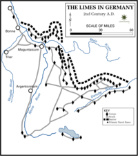
 The limes Germanicus, 2nd century |
|
| UNESCO World Heritage Site | |
|---|---|
| Location | Eastern Europe, North Africa, Western Europe, Western Asia, Roman Empire |
| Includes | Limes Dacicus Antonine Wall Hadrian's Wall Limes Arabicus Limes Germanicus Limes Moesicus Limes Saxoniae Limes Tripolitanus |
| Criteria | ii, iii, iv |
| Reference | 430 |
| Inscription | 1987 (11th Session) |
| Extensions | 2005; 2008 |
|
[]
|
|
A līmes (English: /ˈlaɪmiːz/;Latin pl. līmitēs) was a border defence or delimiting system of Ancient Rome. It marked the boundaries and provinces of the Roman Empire.
The Latin noun limes had a number of different meanings: a path or balk delimiting fields, a boundary line or marker, any road or path, any channel, such as a stream channel, or any distinction or difference.
The word limes was utilized by Latin writers to denote a marked or fortified frontier. This sense has been adapted and extended by modern historians concerned with the frontiers of the Roman Empire: e.g. Hadrian's Wall in the north of England is sometimes styled the Limes Britannicus, the frontier of the Roman province of Arabia facing the desert is called the Limes Arabicus, and so forth.
This was the traditional definition and usage of the term. It is now more common to accept that limes was not a term used by the Romans for the imperial frontier, fortified or not. This is a modern, anachronistic interpretation. The term became common after the 3rd century AD, when it denoted a military district under the command of a dux limitis. Some experts suggested that the limes may actually have been called Munimentum Traiani, Trajan's Bulwark, referring to a passage by Ammianus Marcellinus according to which emperor Julian had reoccupied this fortification in 360 AD.
The limites represented the border line of the Roman Empire at its greatest extent in the 2nd century AD. It stretched over 5,000 km from the Atlantic coast of northern Britain, through Europe to the Black Sea, and from there to the Red Sea and across North Africa to the Atlantic coast. The remains of the limites today consist of vestiges of walls, ditches, forts, fortresses and civilian settlements. Certain elements of the line have been excavated, some reconstructed, and a few destroyed. The two sections of the limes in Germany cover a length of 550 km from the north-west of the country to the Danube in the south-east. The 118 km long Hadrian's Wall was built on the orders of the Emperor Hadrian c. AD 122 at the northernmost limits of the Roman province of Britannia. It is a striking example of the organization of a military zone and illustrates the defensive techniques and geopolitical strategies of ancient Rome. The Antonine Wall, a 60 km-long fortification in Scotland, was started by Emperor Antoninus Pius in AD 142 as a defense against the "Barbarians" of the north. It constitutes the northwestern-most portion of the Roman Limes.
...
Wikipedia
