Freistadt
| Freistadt | ||
|---|---|---|

Linz gate
|
||
|
||
| Location within Austria | ||
| Coordinates: 48°30′42″N 14°30′22″E / 48.51167°N 14.50611°ECoordinates: 48°30′42″N 14°30′22″E / 48.51167°N 14.50611°E | ||
| Country | Austria | |
| State | Upper Austria | |
| District | Freistadt | |
| Government | ||
| • Mayor | Christian Jachs (ÖVP) | |
| Area | ||
| • Total | 12.88 km2 (4.97 sq mi) | |
| Elevation | 560 m (1,840 ft) | |
| Population (14 June 2016) | ||
| • Total | 7,703 | |
| • Density | 600/km2 (1,500/sq mi) | |
| Time zone | CET (UTC+1) | |
| • Summer (DST) | CEST (UTC+2) | |
| Postal code | 4240 | |
| Area code | 07942 | |
| Vehicle registration | FR | |
| Website | www.freistadt.at | |
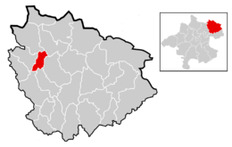
![]() Freistadt (literally "Freetown"; Central Bavarian: Freistod) is a small Austrian town in the state of Upper Austria in the region Mühlviertel. With a population of approximately 7,500 residents, it is a trade centre for local villages. Freistadt is the economic centre of a district of the same name District Freistadt. The nearest sizeable cities are Linz, the capital of Upper Austria, about 40 km in the south, and České Budějovice, the capital of Southern Bohemia, about 60 km in the north.
Freistadt (literally "Freetown"; Central Bavarian: Freistod) is a small Austrian town in the state of Upper Austria in the region Mühlviertel. With a population of approximately 7,500 residents, it is a trade centre for local villages. Freistadt is the economic centre of a district of the same name District Freistadt. The nearest sizeable cities are Linz, the capital of Upper Austria, about 40 km in the south, and České Budějovice, the capital of Southern Bohemia, about 60 km in the north.
The area surrounding Freistadt came under the dominion of the Bavarian Duchy in the seventh century.
Freistadt was founded before 1220. The Babenberg Duke Leopold VI passed through the area in 1225. The earliest mention of Frienstat is in a document from 1241, but in 1277, Rudolf von Habsburg referred to Vreinstat in another document. Its position separated the Habsburg and Bohemian lands, and it stood at crossroads of the valuable salt and iron trade route, which had operated from prehistoric times through the Middle Ages. The outer and inner walls, towers and gates of the old city, built mainly between 1363 and 1393, still exist today.
...
Wikipedia


