Fredericktown-Millsboro, Pennsylvania
| Fredericktown-Millsboro | |
| Former CDP | |
|
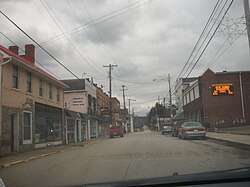
Fredericktown from Route 88
|
|
| Country | United States |
|---|---|
| State | Pennsylvania |
| County | Washington |
| Coordinates | 39°59′42″N 79°59′58″W / 39.99500°N 79.99944°WCoordinates: 39°59′42″N 79°59′58″W / 39.99500°N 79.99944°W |
| Area | 1.8 sq mi (5 km2) |
| Population | 1,094 (2000) |
| Density | 624.3/sq mi (241/km2) |
| Timezone | EST (UTC-4) |
| - summer (DST) | EDT (UTC-5) |
| Area code | 724 |
|
Location of Fredericktown-Millsboro in Washington County
|
|
|
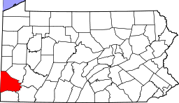
Location of Washington County in Pennsylvania
|
|
|
Location of Pennsylvania in the United States
|
|
Fredericktown-Millsboro was a census-designated place (CDP) in East Bethlehem Township, Washington County, Pennsylvania, United States. The population was 1,094 at the 2000 census. For the 2010 census the area was split into two CDPs, Fredericktown and Millsboro.
The Fredericktown-Millsboro CDP was located at 39°59′42″N 79°59′58″W / 39.99500°N 79.99944°W (39.995095, -79.999370).
According to the United States Census Bureau, the CDP had a total area of 1.8 square miles (4.7 km2), all of it land.
Both Fredericktown and Millsboro are located along the Monongahela River in the river valley. The communities and the surrounding areas are the former homes of bituminous coal mines. The topography has been somewhat altered by the addition of slate dumps: large mounds of coal byproducts have been created on the riverbanks.
As of the census of 2000, there were 1,094 people, 446 households, and 290 families residing in the CDP. The population density was 624.3 people per square mile (241.4/km²). There were 510 housing units at an average density of 291.0/sq mi (112.5/km²). The racial makeup of the CDP was 97.90% White, 1.01% African American, 0.27% Native American, and 0.82% from two or more races. Hispanic or Latino of any race were 0.37% of the population.
...
Wikipedia


