Frederick, South Dakota
| Frederick, South Dakota | |
|---|---|
| City | |
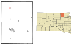
 Location in Brown County and the state of South Dakota |
|
| Coordinates: 45°49′58″N 98°30′25″W / 45.83278°N 98.50694°WCoordinates: 45°49′58″N 98°30′25″W / 45.83278°N 98.50694°W | |
| Country | United States |
| State | South Dakota |
| County | Brown |
| Incorporated | 1882 |
| Area | |
| • Total | 0.39 sq mi (1.01 km2) |
| • Land | 0.39 sq mi (1.01 km2) |
| • Water | 0 sq mi (0 km2) |
| Elevation | 1,381 ft (421 m) |
| Population (2010) | |
| • Total | 199 |
| • Estimate (2015) | 204 |
| • Density | 510.3/sq mi (197.0/km2) |
| Time zone | Central (CST) (UTC-6) |
| • Summer (DST) | CDT (UTC-5) |
| ZIP code | 57441 |
| Area code(s) | 605 |
| FIPS code | 46-22860 |
| GNIS feature ID | 1255150 |
Frederick is a town in Brown County, South Dakota, United States. The population was 199 at the 2010 census. Home to the annual Frederick Finn Fest, the town is part of the Aberdeen Micropolitan Statistical Area.
Frederick was a railway town platted and sold to pioneers by the Chicago, Milwaukee & St. Paul Railroad, which completed track into it on September 12, 1881. Its grid of blocks was aligned by compass, with numbered avenues running north-south, and numbered streets running east-west. Main Street and Railway Avenue intersect at the grid's core. Incorporated on June 21, 1882, Frederick was named after the railroad's Finnish immigration agent and sales clerk—Kustaa "Frederick" Bergstadius.
Frederick is located at 45°49′58″N 98°30′25″W / 45.83278°N 98.50694°W (45.832812, -98.507026).
According to the United States Census Bureau, the town has a total area of 0.39 square miles (1.01 km2), all land. Frederick is drained by the Maple River.
The town is connected by ![]() U.S. Route 281.
U.S. Route 281.
...
Wikipedia
