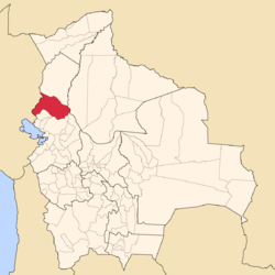
Franz Tamayo Province
| Franz Tamayo Province | |
|---|---|
| Province | |

Chalalan Lake
|
|
 Location of Franz Tamayo Province within Bolivia |
|
 Provinces of the La Paz Department |
|
| Coordinates: 16°0′0″S 67°5′0″W / 16.00000°S 67.08333°W | |
| Country |
|
| Department | La Paz Department |
| Municipalities | 2 |
| Cantons | 9 |
| Capital | Apolo |
| Area | |
| • Total | 15,900 km2 (6,100 sq mi) |
| Population (2012 census) | |
| • Total | 26,997 |
| • Density | 1.7/km2 (4.4/sq mi) |
| • Ethnicities | Quechua, Aymara |
| Area code(s) | BO.LP.FT |
| Website | Official website |
Franz Tamayo is a province in the Bolivian department of La Paz. It lies in the western part of the nation, and includes the Ulla Ulla National Reserve - which today is part of the Apolobamba Integrated Management Natural Area - in the high Andean plain on the western border with Peru. Its capital is Apolo.
The province was founded with the name Caupollcán on January 23, 1826. On December 20, 1967 the name was changed in honor of the Bolivian intellectual, writer and politician Franz Tamayo (1878–1956).
The Apolobamba mountain range traverses the province. The highest mountain of the province is Chawpi Urqu (Wisk'achani) at 6,044 m (19,829 ft). Other mountains are listed below:
Franz Tamayo Province is divided into two municipalities which are further subdivided into nine cantons.
Some of the tourist attractions of the municipalities are:
Other remarkable places are Pilón Lajas Biosphere Reserve and Communal Lands, Chalalan Lake and Chalalan ecolodge.
Coordinates: 16°00′S 67°05′W / 16.000°S 67.083°W
...
Wikipedia
