
Fränkisch-Crumbach
| Fränkisch-Crumbach | ||
|---|---|---|
|
||

Fränkisch-Crumbach
|
||
|
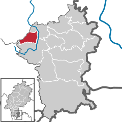
Location of Fränkisch-Crumbach within Odenwaldkreis district
  |
||
| Coordinates: 49°45′N 08°52′E / 49.750°N 8.867°ECoordinates: 49°45′N 08°52′E / 49.750°N 8.867°E | ||
| Country | Germany | |
| State | Hesse | |
| Admin. region | Darmstadt | |
| District | Odenwaldkreis | |
| Government | ||
| • Mayor | Gerhard Maser (SPD) | |
| Area | ||
| • Total | 16.1 km2 (6.2 sq mi) | |
| Elevation | 190-500 m (−1,450 ft) | |
| Population (2015-12-31) | ||
| • Total | 3,184 | |
| • Density | 200/km2 (510/sq mi) | |
| Time zone | CET/CEST (UTC+1/+2) | |
| Postal codes | 64407 | |
| Dialling codes | 06164 | |
| Vehicle registration | ERB | |
| Website | www.fraenkisch-crumbach.de | |

Fränkisch-Crumbach is a community in the Odenwaldkreis (district) in Hesse, Germany.
Fränkisch-Crumbach lies in the middle Odenwald on the Gersprenz, which empties into the Main near .
Fränkisch-Crumbach borders in the northeast on the community of Brensbach, in the southeast on the community of Reichelsheim (both in the Odenwaldkreis), in the west on the town of Lindenfels (Kreis Bergstraße), in the northwest on the community of Fischbachtal and in the north on the town of Groß-Bieberau (both in Darmstadt-Dieburg).
The municipal election held on 26 March 2006 yielded the following results:
Mayor Gerhard Maser (SPD) was re-elected in the runoff election on 6 March 2005 with 60.8% of the vote.
The community is linked to the long-distance road network by Bundesstraße 38 (Weinheim–Roßdorf).
...
Wikipedia