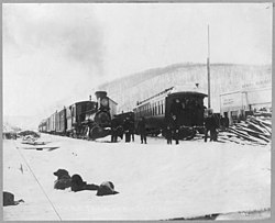
Fox, Alaska
| Fox, Alaska | |
|---|---|
| Census-designated place | |

Trains of the Tanana Valley Railroad at the station in Fox, Alaska, in 1916
|
|
 Location within Fairbanks North Star Borough and the state of Alaska |
|
| Coordinates: 64°57′14″N 147°37′42″W / 64.95389°N 147.62833°WCoordinates: 64°57′14″N 147°37′42″W / 64.95389°N 147.62833°W | |
| Country | United States |
| State | Alaska |
| Borough | Fairbanks North Star |
| Government | |
| • Borough mayor | Karl Kassel |
| • State senators |
Click Bishop (R) John Coghill (R) |
| • State reps. |
David Guttenberg (D) Dave Talerico (R) |
| Area | |
| • Total | 13.1 sq mi (33.9 km2) |
| • Land | 13.1 sq mi (33.9 km2) |
| • Water | 0 sq mi (0 km2) |
| Elevation | 751 ft (229 m) |
| Population (2010) | |
| • Total | 417 |
| • Density | 32/sq mi (12.3/km2) |
| Time zone | Alaska (AKST) (UTC-9) |
| • Summer (DST) | AKDT (UTC-8) |
| ZIP code | 99712 |
| Area code(s) | 907 |
| FIPS code | 02-26870 |
| GNIS feature ID | 1402342 |
Fox is a census-designated place (CDP) in Fairbanks North Star Borough, Alaska, United States. It is part of the Fairbanks, Alaska Metropolitan Statistical Area. At the 2010 census the population was 417.
Fox is located at 64°57′14″N 147°37′42″W / 64.95389°N 147.62833°W (64.953979, -147.628325), on the bank of Fox Creek as it enters Goldstream Creek Valley, 10 mi (16 km) northeast of Fairbanks. Steese Highway and Elliott Highway intersect in Fox.
Established as a mining camp in the early 1900s, Fox functions as a bedroom community today and most residents work in nearby Fairbanks or at Fort Knox Gold Mine to the northeast.
According to the United States Census Bureau, the CDP has a total area of 13.1 square miles (33.9 km2), all of it land.
As of 2007, there were 353 people, 119 households, and 71 families residing in the CDP. The population density was 22.1 people per square mile (8.5/km²). There were 159 housing units at an average density of 11.7/sq mi (4.5/km²). The racial makeup of the CDP was 87.67% White, 8.00% Native American, 0.33% Asian, 1.33% from other races, and 2.67% from two or more races. 1.33% of the population were Hispanic or Latino of any race.
...
Wikipedia
