Four Corners, FL
|
Four Corners, Florida Citrus Ridge |
|
|---|---|
| Unincorporated area; Census-designated place |
|
 Location in Lake County and the state of Florida |
|
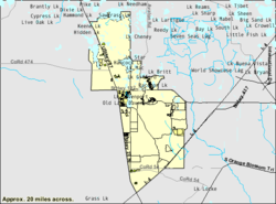
 U.S. Census Bureau map showing CDP boundaries |
|
| Coordinates: 28°20′1″N 81°38′33″W / 28.33361°N 81.64250°WCoordinates: 28°20′1″N 81°38′33″W / 28.33361°N 81.64250°W | |
| Country | United States |
| State | Florida |
| County | Lake, Polk, Osceola, Orange |
| Area | |
| • Total | 50.1 sq mi (129.8 km2) |
| • Land | 46.4 sq mi (120.1 km2) |
| • Water | 3.7 sq mi (9.7 km2) |
| Population (2010) | |
| • Total | 26,116 |
| • Density | 520/sq mi (200/km2) |
| Time zone | Eastern (EST) (UTC-5) |
| • Summer (DST) | EDT (UTC-4) |
| ZIP code | 32966, 32968, 32969 |
| FIPS code | 12-12435 |
Four Corners, also known as Citrus Ridge, is an unincorporated area and census-designated place (CDP) in the U.S. state of Florida, located at a quadripoint formed by Lake, Orange, Osceola and Polk counties. The population of the Four Corners CDP was 26,116 at the 2010 census.
The Lake, Orange, and Osceola County portions of Four Corners are part of the Orlando–Kissimmee–Sanford, Florida Metropolitan Statistical Area, while the Polk County portion is part of the Lakeland–Winter Haven Metropolitan Statistical Area.
Four Corners is located at 28°20′1″N 81°38′33″W / 28.33361°N 81.64250°W (28.333701, -81.642451).
According to the United States Census Bureau, the Four Corners CDP has a total area of 50.1 square miles (129.8 km2), of which 46.4 square miles (120.1 km2) is land and 3.7 square miles (9.7 km2), or 7.49%, is water.
The United States Census Bureau area is based on census tracts. The complete area of Four Corners is larger and can be described as north along US 27 to Lake Louisa State Park (4 miles north of US 192), south along US 27 to Heart of Florida Hospital (3 miles south of I-4), west to SR 33, and east to Walt Disney World and Celebration. Four Corners has a total area of 180 square miles (470 km2). Four Corners is the only community in Florida to be located in four counties.
...
Wikipedia
