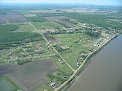
Fort Vermilion
| Fort Vermilion | |||
|---|---|---|---|
| Hamlet | |||

Aerial view from north
|
|||
|
|||
| Coordinates: 58°23′24″N 116°01′00″W / 58.39000°N 116.01667°WCoordinates: 58°23′24″N 116°01′00″W / 58.39000°N 116.01667°W | |||
| Country |
|
||
| Province |
|
||
| Region | Northern Alberta | ||
| Census division | 17 | ||
| Specialized municipality | Mackenzie County | ||
| Established | 1788 (oldest in Alberta) | ||
| Government | |||
| • Type | Unincorporated | ||
| • Reeve | Bill Neufeld | ||
| • Governing body |
Mackenzie County Council
|
||
| • MP | Arnold Viersen (Cons - Peace River—Westlock) | ||
| • MLA | Debbie Jabbour (NDP - Peace River) | ||
| Area | |||
| • Total | 6.81 km2 (2.63 sq mi) | ||
| Elevation | 270 m (890 ft) | ||
| Population (2011) | |||
| • Total | 727 | ||
| • Density | 110/km2 (280/sq mi) | ||
| • Dwellings | 278 | ||
| Time zone | MST (UTC−7) | ||
| • Summer (DST) | MDT (UTC−6) | ||
| Postal code | T0H 1N0 | ||
| Area code(s) | +1-780 | ||
| Highways | Highway 88 (Bicentennial Highway) | ||
| Waterways | Peace River | ||
Fort Vermilion is a hamlet on the Peace River in northern Alberta, Canada, within Mackenzie County.
Established in 1788, Fort Vermilion shares the title of oldest European settlement in Alberta with Fort Chipewyan. Fort Vermilion contains many modern amenities to serve its inhabitants as well as the surrounding rural community. The municipal office of Mackenzie County, Alberta's largest municipality by land area, is located in Fort Vermilion.
The hamlet is located in census division No. 17.
The area was inhabited by Dunneza (Beaver), Dene and later Cree first nations long before the arrival of European traders and settlers.
Named for the vermilion coloured clays lining the river banks, Fort Vermilion began as a trading community for the North West Company, upstream of the impassible Vermilion Chutes. The fort was established in 1788, following the expeditions of Alexander MacKenzie. Winter residents would trade furs with the native trappers, then send the furs by river during the summer to exchange points to the east and then to Montreal. The fort was later transferred to the Hudson's Bay Company after the 1821 merger. By 1830, it was a prosperous fur trading post. The first Anglican church was built in 1877.
The main access to the settlements was by means of the river, using river boats and then ferries to haul materials in the summer months, when the water was not frozen. In 1903 the first steam-powered vessel to serve Fort Vermilion was the St. Charles built to navigate the 526 miles (847 km) the upper reaches of the Peace River, from Hudson's Hope to Fort Vermilion. In 1974 a bridge was built over the Peace River immediately west of Fort Vermilion, effectively ending the winter isolation of the community.
...
Wikipedia


