Fort Riley (CDP), Kansas
|
Fort Riley, Kansas Fort Riley North |
|
|---|---|
| Census-designated place | |
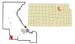
 Location within Riley County and Kansas |
|
| Coordinates: 39°5′18″N 96°48′51″W / 39.08833°N 96.81417°WCoordinates: 39°5′18″N 96°48′51″W / 39.08833°N 96.81417°W | |
| Country | United States |
| State | Kansas |
| Counties | Riley, Geary |
| Area | |
| • Total | 5.05 sq mi (13.07 km2) |
| • Land | 5.03 sq mi (13.04 km2) |
| • Water | 0.008 sq mi (0.02 km2) |
| Elevation | 1,210 ft (370 m) |
| Population (2010) | |
| • Total | 7,761 |
| • Density | 1,500/sq mi (590/km2) |
| Time zone | Central (CST) (UTC-6) |
| • Summer (DST) | CDT (UTC-5) |
| FIPS code | 20-23975 |
Fort Riley is a census-designated place (CDP) that covers part of Fort Riley, a US Army installation in Geary and Riley counties in the U.S. state of Kansas. The population was 7,761 at the 2010 census, down from 8,114 at the 2000 census, at which time the CDP was known as Fort Riley North.
The area is more commonly known as "Custer Hill".
The Fort Riley CDP is located primarily in southern Riley County at 39°5′18″N 96°48′51″W / 39.08833°N 96.81417°W (39.088222, -96.814092). A small portion of the CDP crosses the county line south into Geary County. According to the United States Census Bureau, the CDP has a total area of 5.1 square miles (13.1 km2), of which 0.01 square miles (0.02 km2), or 0.17%, is water. It is 6 miles (10 km) north of Junction City and 16 miles (26 km) southwest of Manhattan, Kansas.
Fort Riley is part of the Manhattan, Kansas Metropolitan Statistical Area.
As of the census of 2000, there were 8,114 people, 1,305 households, and 1,277 families residing in the CDP. The population density was 613.1/km² (1,586.7/mi²). There were 1,335 housing units at an average density of 100.9/km² (261.1/mi²). The racial makeup of the CDP was 60.0% White, 24.6% African American, 1.2% Native American, 2.1% Asian, 0.6% Pacific Islander, 6.3% from other races, and 5.2% from two or more races. Hispanic or Latino of any race were 13.0% of the population.
...
Wikipedia
