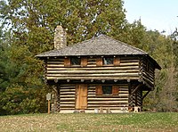
Fort Ouiatenon
| Fort Ouiatenon | |
|---|---|
| West Lafayette, Indiana | |

The replica of the blockhouse
|
|
| Type | Fort |
| Site information | |
| Controlled by | New France; Great Britain; First Nations |
| Site history | |
| Built | 1717 |
| In use | 1717–1763 |
| Garrison information | |
| Past commanders |
François-Marie Bissot(Fr); Edward Jenkins(Br) |
|
Fort Ouiatenon
|
|

Fields at the site
|
|
| Nearest city | Lafayette, Indiana |
| Area | 17.5 acres (7.1 ha) |
| Built | 1717 |
| NRHP Reference # | 70000008 |
| Added to NRHP | February 16, 1970 |
Fort Ouiatenon, built in 1717, was the first fortified European settlement in what is now called Indiana. It was a French trading post on the Wabash River located approximately three miles southwest of modern-day West Lafayette. The name 'Ouiatenon' is a French rendering of the name in the Wea language, waayaahtanonki, meaning 'place of the whirlpool'.
Every year between the end of September and the month of October, a reenactment of pioneer life called the Feast of the Hunters' Moon is held at the rebuilt fort.
Fort Ouiatenon was originally constructed by the Government of New France as a military outpost to protect against Great Britain’s western expansion. Its location among the unsettled woodlands of the Wabash River valley also made it a key center of trade for fur trappers. French merchants and trappers from Quebec would arrive at Fort Ouiatenon in search of beaver pelts and to take advantage of trade relations with the native Wea Indian tribes.
In 1717, Ensign François Picote de Beletre (related to another Picoté de Bélestre, see Adam Dollard des Ormeaux) arrived at the mouth of the Tippecanoe and Wabash with four soldiers, three men, a blacksmith and supplies to trade with the nearby Wea people, an Algonquian-speaking nation closely related to the Miami people. They built a stockade on the Wabash, eighteen miles below the mouth of the Tippecanoe. François-Marie Bissot, the Sieur de Vincennes assumed command of the fort sometime in the 1720s. The French settled on the north bank, with Wea villages on the south bank. The boundary between the French colonies of Louisiana and Canada, although inexact in the first years of the settlement, was decreed in 1745 to run between Ouiatenon and Fort Vincennes.
...
Wikipedia


