Fort Hunter Liggett
| Fort Hunter Liggett | |
|---|---|
| Monterey County, California, USA | |

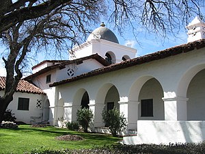
A public hotel within Fort Hunter Liggett
|
|
| Coordinates | 35°57′08″N 121°13′50″W / 35.952226°N 121.23065°W |
| Type | Training Reservation/military base |
| Site information | |
| Owner | United States Army |
| Controlled by | IMCOM-West |
| Open to the public |
Yes |
| Condition | Active, In Use |
| Website | www |
| Site history | |
| Built | 1940 |
| In use | 1940–Present |
| Garrison information | |
| Current commander |
Colonel Jan Norris |
| Garrison |
80th Division (IT) 91st Training Division (Operations) |
Fort Hunter Liggett (US Army Garrison, Fort Hunter Liggett (USAG, FHL)), named after General Hunter Liggett in 1941, is a United States Army fort in southern Monterey County, California, about 250 miles (400 km) north of Los Angeles and 150 miles (240 km) south of San Francisco. The fort is primarily used as a training facility, where activities such as field maneuvers and live fire exercises are performed. It is roughly 25 miles northwest of Camp Roberts, California.
The Salinas Valley is the fort's northern border, the Santa Lucia Mountains bound it on the east, Los Padres National Forest on the west and the Monterey and San Luis Obispo County line on the south. The fort originally comprised 200,000 acres (81,000 ha), but even at its present size of 167,000 acres (68,000 ha), it is the largest United States Army Reserve command post.
Some of the land, 52 acres (21 ha), was given to Mission San Antonio de Padua, bringing its size to 85 acres (34 ha). Additionally, land has been traded between the United States Forest Service, which owns the adjacent Los Padres National Forest, and the Army. Junipero Serra Peak or Pimkolam (Native American name), formerly called Santa Lucia Peak, is to the north and Bald Mountain to the south. The fort also contains the headwaters of the Nacimiento River and San Antonio River. The opening helicopter scene of We Were Soldiers was filmed at the old Bailey Bridge spanning the San Antonio.
...
Wikipedia
